|
||

|

|
|

|
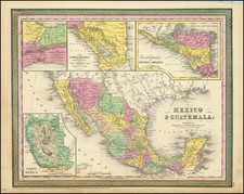
Map Showing part of Inyo, Kern, and Tulare Counties, produced by George Cram in Chicago in 1892, offers a comprehensive cartographic depiction of a vital section of California's Central Valley during a period of notable transition. This piece notably traces the route of the Southern Pacific through Bakersfield, underscoring the significance of rail transport in the region's development. In addition, the evolving shorelines of Buena Vista Lake, Kern Lake, and the southern portion of Lake Tulare, as recorded in the years 1854, 1880, and 1884, are meticulously delineated, capturing the environmental shifts of the era.
The late 19th century was a time of intense change for California, both ecologically and infrastructurally. The construction of the Southern Pacific railway heralded an era of greater connectivity and economic growth, turning towns such as Bakersfield into burgeoning hubs. The accessibility offered by such railroads accelerated the movement of goods, people, and ideas, fundamentally reshaping the demographic and economic landscape of the region.
Cram's choice to depict the changing shorelines of the region's most famous phantom lake provides a fascinating glimpse into the environmental history of California. The varying shoreline, captured over a 30-year span, highlights the hydrological changes, likely driven by both natural fluctuations and human interventions. Such modifications would have had direct implications for agriculture, settlement, and trade, attesting to the interplay between humans and their environment.
George Cram's map is not merely a geographical representation, but a document of the period's socio-economic and environmental dynamism. The intertwining narratives of infrastructural development and environmental shifts offer scholars a rich tapestry of the late 19th-century Californian milieu, reflecting the broader challenges and opportunities faced by the American West during this epoch.
George F. Cram (1842-1928), or George Franklin Cram, was an American mapmaker and businessman. During the Civil War, Cram served under General William Tecumseh Sherman and participated in his March to the Sea. His letters of that time are now important sources for historians of the Civil War. In 1867, Cram and his uncle, Rufus Blanchard, began the company known by their names in Evanston, Illinois.
Two years later, Cram became sole proprietor and the company was henceforth known as George F. Cram Co. Specializing in atlases, Cram was one of the first American companies to publish a world atlas. One of their most famous products was the Unrivaled Atlas of the World, in print from the 1880s to the 1950s.
Cram died in 1928, seven years after he had merged the business with that of a customer, E.A. Peterson. The new company still bore Cram’s name. Four years later, the Cram Company began to make globes, a branch of the business that would continue until 2012, when the company ceased to operate. For the final several decades of the company’s existence it was controlled by the Douthit family, who sold it just before the company was shuttered.