|
||

|

|
|

|
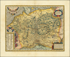
In the aftermath of World War I, the notion of national self-determination, championed by leaders like President Woodrow Wilson, became a foundational principle for the restructuring of Europe. The intent was to create nations based on shared ethnicity, language, and culture, thereby promoting peace through homogeneity. Dr. Wilhelm Winkler’s map, titled Völker und Staaten in Mitteleuropa (Peoples and States in Central Europe), engages with this principle, yet presents it from a perspective emphasizing the perceived injustices faced by the German nation.
At first glance, the map seems to be a careful representation of the ethnic groups in Central Europe. A variety of colors and patterns demarcate the presence of different populations, from Germans and Poles to Slovaks and Italians. However, beyond this visual presentation, the map possesses a deeper political message.
Dr. Winkler, through the cartographic choices, seems to emphasize the fragmented distribution of German-speaking populations across Central Europe. Large swaths of red, indicative of German regions, are not limited to the boundaries of post-WWI Germany but spill over into areas such as Austria, Czechoslovakia, Poland, and Denmark. By visualizing these distributed German populations, Winkler challenges the post-war territorial settlements, arguing that they fail to encapsulate the entirety of the German nation.
The context is crucial. The Treaty of Versailles and other treaties redrew the borders of Europe, often at the expense of the Central Powers, particularly Germany. While the Allies championed the principle of national self-determination, the application was arguably selective. Dr. Winkler’s map suggests this hypocrisy by highlighting the presence of German minorities outside the Weimar Republic’s borders, insinuating that the Allies, by not allowing these regions to join Germany, violated the very principle they propagated.
Furthermore, the detailed statistics provided alongside the map reinforce this argument. By enumerating the significant numbers of German speakers in regions outside Germany, Winkler strengthens the case for a broader German territory based on linguistic and ethnic unity.
Wilhelm Winkler and the Paradox of the Mitteleuropa Map
The first half of the 20th century witnessed seismic shifts in political ideologies, borders, and national identities. Within this whirlwind of change, figures like Wilhelm Winkler emerge as perplexing enigmas. On one hand, Winkler's biography paints a picture of an Austrian patriot, devoted to his homeland, and on the other, a progressive thinker who championed minority rights and would face persecution for both his personal and professional choices. This dichotomy raises questions about the “Völker und Staaten in Mitteleuropa” map and the motivations behind its creation.
Given Winkler's biography, it might initially seem contradictory that a map with seemingly pro-German inclinations was attributed to him. Winkler, after all, was an outspoken proponent of mistreated European minorities and would later face dire consequences for his beliefs after the Nazi annexation of Austria. Moreover, his personal life, especially his marriage to a Jewish woman, would seemingly position him in direct opposition to German nationalist aspirations and proto-Nazi ideologies.
However, this apparent contradiction might be better understood by distinguishing between the concepts of German nationalism in the immediate post-WWI era and the virulent strain of Nazism that emerged in the 1930s. In the aftermath of WWI, there was a broad consensus among German-speaking populations about the perceived injustices of the Treaty of Versailles, especially the drawing of borders that left significant German-speaking minorities outside the new German state. Winkler's map could be seen as an expression of this sentiment, emphasizing the presence of German-speaking communities outside the Weimar Republic's borders.
This emphasis on German-speaking communities doesn't necessarily align Winkler with aggressive expansionist ideologies. Given his progressive stance on minority rights, the map could be interpreted as a plea for self-determination and minority representation, rather than territorial aggrandizement. Winkler's work in minority population studies further supports this interpretation, suggesting that his aim might have been to highlight the complexity of national identities in Central Europe and argue for a more nuanced understanding of borders and nationhood.
Translation of Text at the Right
In particular, there are 400,000 South Slavs in the former Austrian coastal region, which were annexed by Italy without a referendum. Danzig was made a vassal state of Poland without a referendum, and the so-called Polish Corridor, which separates East Prussia from Germany, was also annexed by Poland without a referendum, both to give Poland access to the sea. Switzerland does not have a corridor to Genoa, Czechoslovakia does not have one to Hamburg, and the German-Austria had renounced its rights to the corridor to Trieste (the Austrian coastal region) as early as 1918 due to the right of self-determination since this area is mainly inhabited by South Slavs. The partitioning of Upper Silesia by the League of Nations did not follow the results of the popular vote, but the border was shifted in favor of Poland.
German-Austria and the German parts of Bohemia, Moravia, and Silesia adjacent to the German Reich declared their unification with the German Empire unanimously on November 12, 1918, through their representatives elected under universal, equal, and direct voting rights. The latter territories were then occupied by Czech troops and annexed by Czechoslovakia without a referendum. German-Austria was forced to renounce its right to self-determination in the Treaty of St. Germain.
The Carpatho-Ruthenian region (433,000 Ukrainians in the east of Czechoslovakia) was promised the most extensive self-administration compatible with the unity of the Czechoslovak state in a treaty from St. Germain on September 10, 1919. However, this self-administration was not granted. The densely populated 3.1 million Germans, 1.7 million Slovaks, 0.8 million Hungarians of Czechoslovakia, 4.8 million Ukrainians, and 0.6 million Germans of Poland as well as other large national minorities created by the peace treaties were not promised any self-administration.
![(Second World War - Operation Barbarossa) A M. Kir. VIII. Honv. LGV. O. Hazamenetelének útja mecsebjelovkától kassáig [The Hungarian 8th Anti-Aircraft Battalion's Homeward Route from Mechebylove to Kosice]](https://storage.googleapis.com/raremaps/img/small/90242.jpg)
![(Florida Aviation - Early Photographs) [Original photograph album of Carlstrom Field, Florida, early Army Air Service Training Camp]](https://storage.googleapis.com/raremaps/img/small/84163.jpg)
![[ Postal Map of Eastern Europe ] Deutschlands Postkarte begraenzt von Oesterrreich, Preussen, Frankreich, Holland, Italien und der Schweiz. Gezeichnet und Herausgegeben von Ignaz Heymann. K.K. Obserpostamtsoffizier in Trieste. 1800.](https://storage.googleapis.com/raremaps/img/small/77678.jpg)