|
||

|

|
|

|
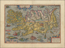
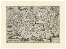
Fine miniature map of Iceland from the late 17th Century, which vividly captures the formidable beauty of Iceland, emphasizing its rugged coastlines and the towering heights of its mountainous terrain.
Perhaps the most striking feature is the eruption of Mt. Hecla, a testament to Iceland's volatile geology, anticipating by 15 years the next example of Hecla's fury in 1693. Hecla is became emblematic of Iceland's dramatic and unpredictable landscape.
The map illustrates two larger towns - Skalholt and Hola. Skálholt, situated in southern Iceland, is steeped in ecclesiastical and cultural history. For over 700 years, from the 11th to the 18th century, it was one of Iceland's two main episcopal sees, alongside Hólar, making it a focal point of religious power, education, and culture. Bishop Ísleifur Gissurarson, consecrated in 1056, established the bishopric of Skálholt. Throughout the Middle Ages, Skálholt thrived as a center for learning, with its own school that fostered education and the preservation of knowledge.
Hólar, located in the northern part of Iceland in the Hjaltadalur valley, holds a special place in Icelandic history as an epicenter of education, culture, and ecclesiastical power. Established in 1106 AD by Bishop Jón Ögmundsson, Hólar served as the seat of northern bishops for over seven centuries, rivaling the southern bishopric of Skálholt. The Hólar Cathedral, a prominent landmark, is one of the oldest stone churches in Iceland.
The map's detaild draws from a map of Iceland by Jodocus Hondius the Younger, who relied in turn upon manuscript work by Joris Carolus. Carolus's journey from a wounded soldier at the Siege of Ostend to a pilot and maker is as fascinating as the maps he crafted. His claims of voyages to the distant reaches of the north, though often shrouded in mystery and skepticism, brought forward new geographic knowledge, if not always accurate.
Of particular interest is Carolus's stay in Iceland. There, he engaged with local scholar Jon Gudmundsson and acquainted himself with the island's unique geography and culture. He relied on the map of Bishop Gudbrandur, to shape his own portrayal of Iceland. This cartographic lineage left a lasting legacy. For over a hundred years, Joris Carolus's map informed and influenced the portrayal of Iceland, becoming a touchstone for other mapmakers, even as they made minor alterations.
Iceland's history, as captured in maps like Du Val's, offers a window into its unique saga. From the discovery of its shores by the Norsemen in the 9th century to its establishment as a unique political and cultural entity, Iceland's tale is rich and varied. Its early settlers forged a democratic tradition in the Althing, and Iceland's conversion to Christianity in 1000 AD under Norwegian influence marked a significant chapter in its cultural evolution.
By the 17th century, when Du Val etched Iceland's contours on his map, the island was a tapestry of history, geography, and culture. Its people, scattered across vast landscapes, held onto the stories of their Norse ancestors while navigating the challenges and opportunities of their time.


![Denmark [inset of Iceland]](https://storage.googleapis.com/raremaps/img/small/72587.jpg)