|
||

|

|
|

|
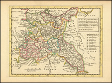
Constructed for King Stanisław August Poniatowski (Stanislaus II Augustus).
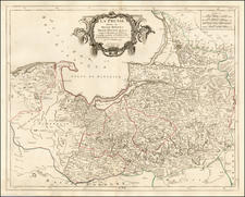
Monumental map of Poland the the Grand Duchy of Lithuania, published in Warsaw and dated 1770, produced on a scale of 1:1,300,000, this remarkable map is the product of an amalgam of work largely produced by Karol Herman de Perthees, who was then serving as the official mapmaker to King Stanislaus II Augustus and his predecessor, Francisek Florian Czaki.
The map is of significant interest for several reasons. First, it is seemingly an entirely Polish production, engraved in Warsaw and constructed from manuscript maps created for the Poland's King. It is also a singificant leap forward in detail and accuracy, most notably being the earliest printed maps of Poland to include post roads and postal towns at such a granular level. Settlements and post stations are densely marked along the roads.
Overview
In the waning years of Augustus III's rule, Poland experienced a burst cartographic initiatives. Numerous maps of varied scales emerged. Many of these maps were produced during the outset of Stanislas Augustus's reign, their origins often shrouded in mystery, as many have not survived and most only exist in manuscript form.
The late 18th century was a period marked by geopolitical tumult in the region, with Russian military's aggression rendering maps of Poland essential for combatants on all sides. Poland's engagement in the wars of succession, the Seven Years War, and confrontations against the Confederacy of Bar highlighted this pressing need.
Mapping The Region Prior To The First Polish Partition
Amidst this backdrop, two maps prominently stand out. The first, the Regni Poloniae, Magni Ducatus Lithuaniae, Provinciarum Foedere et Vasallagio illis iunctarum et Regionum vicinarum Nova Mappa Geographica, a 16 sheet map dated 1770, published in 1771 in Konigsburg by Jan Jakub Kanter, seemingly drew inspiration from Polish manuscript sources is perhaps the most famous. The most notable of these sources was Francisek Florian Czaki, who brought with him a drove of 201 maps to the Polish court from the Library of Prince J.A. Jablonski, which were ultimately sold to King Stanislaus II Augustus. This map would later be reproduced in a 4 sheet edition in Nuremberg in 1773 and later in Amsterdam in 1788.
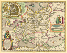
The second map, entirely conceptualized and produced in Poland, is Bartolomeo Folino's engraved "Carte générale et nouvelle de toutte la Pologne, du Grand Duché Lithuanie et de pays limitrophes." Dated 1770 and published in Warsaw, the map is enigmatic. Initial beliefs credited Anthony Hiż and Folino as its creators, but this is unlikely as Folino was an Italian painter and engraver. As noted by Bukzec,
The prospectus announcing this map published by the well-known Warsaw bookseller Michael Gröll stated that it was made “d'après la Carte de S.A. Monsgr le Prince Repnin", whereas on the manuscript copy of the map bought by the King of Prussia, Frederick II, in 1770 there was the name of Anthony Hiż, an officer of the Lithuanian Foot Guards. But neither Hiż nor Bartholomew Folino were the authors of this map and it was not of Russian origin: it was closely connected on the one hand with the cartographic works of Prince J.A. Jablonowski, resembling in some respects the map of Poland made under the Prince's supervision by J.A. Rizzi-Zannoni, and on the other to the works of Charles de Perthées, the main executor of the cartographic projects of the Polish King, Stanislas Augustus.
As noted by Buczek, the map origins can be traced largely to the work of Charles de Perthées and Francisek Florian Czaki, drawing from early surveys brought by Czaki and updated information which post dated the Polish delimitation survey of the border of the Grand Duchy of Lithuania with Russia (1766-67), which appear on Perthees's maps, as well as the addition of the Oginski Canal, built between 1765 and 1783 and financed by Kazimierz Oginski.
A smaller version of the map was published by Michel Groll (Michał Gröll) in Warsaw in 1773 (Carte Generale & Itineraire de Pologne). The original 4 sheet map was also copied by Rizzi Zannoni.
Rarity
The map survives in a few Eastern European institutions, but we are unaware of any examples appearing on the market.
Karol Herman de Perthées, primarily known as Karol Perthées, was born to a family of French Huguenots in Dresden on January 14, 1740.
Born as the illegitimate son of Herman Karl von Keyserling, Perthées was named both Herman and Karol, yet he chose to go by the latter throughout his life. His formal education began in military school in Berlin, where he was trained in military engineering.
In 1764, Perthées' was appointed as the court geographer and map-maker to Stanisław August Poniatowski, the last king and Grand Duke of the Polish-Lithuanian Commonwealth. During this time, he created a series of 1:225,000 scale maps detailing the provinces of the Republic of Poland. Five of these maps were published in Paris. In 1798 he lectured on cartography for the Russian army in Vilnius
He also produced the Carte hydrographique de Pologne, in 1809.
Apart from his work as a mapmaker, Perthées amassed an impressive collection of insects, meticulously documenting about 2,600 species. These invaluable records became a part of Vilnius University's collection in 1823, which were destroyed during World War II in 1943.
Perthées’ married Józefa, the daughter of the renowned Italian painter Bernardo Bellotto. After her death in 1789, he married her sister, Teresa, in 1792.
![[Gulf of Finland / Narva / Vyborg] Pascaarte vande Lijflandsche zee, van Revel en Elsenvos tot het uijterste der Oost-zee](https://storage.googleapis.com/raremaps/img/small/75076.jpg)