|
||

|

|
|

|
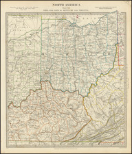
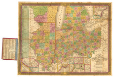
Ohio, a detailed map of the state published by Thomas Gamaliel Bradford in Boston in 1846, offers an insightful depiction of Ohio's counties, towns, rivers, lakes, roads, and other significant features. Hand-colored by counties and corrected to the year 1846, this scarce late edition serves as a snapshot of Ohio's geography during a pivotal period in American history.
The mid-19th century was a time of profound transformation in the United States, with the expansion of transportation networks, growth of cities, and the political complexities leading to the Civil War. Ohio, positioned as a critical gateway to the West, was experiencing tremendous growth and change. The state was an essential hub for canals and emerging railroads, and its burgeoning industries attracted a diverse population. Bradford's map captures this dynamic period, illustrating not only the political boundaries and natural features but also the vital transportation routes that were shaping the state's development.
Thomas Gamaliel Bradford, the publisher of this map, was a prominent figure in American cartography. His works are noted for their clarity, accuracy, and aesthetic appeal. The map's hand-coloring by counties adds to its visual attractiveness, allowing for easy differentiation between regions. The notation "Corrected to 1846" indicates Bradford's commitment to ensuring that the map reflected the most current information, a crucial aspect for users during this rapidly changing era.
The specificity of the map, with its careful delineation of towns, waterways, and roads, provides a detailed view of Ohio's landscape. It captures the intricacy of human settlement and the natural environment, reflecting the complex interplay between these elements. This precision makes the map more than a mere geographical representation; it serves as a historical document, bearing witness to the social and economic forces shaping Ohio in the mid-19th century.
In summary, Ohio by Thomas Gamaliel Bradford stands as an exceptional cartographic work that encapsulates the essence of a state in transition. It combines geographical accuracy, aesthetic quality, and historical relevance, providing a comprehensive view of Ohio during a time of significant growth and change. Its depiction of counties, transportation networks, and natural features offers a nuanced perspective of a region at the heart of America's westward expansion, reflecting the broader currents of a nation on the brink of transformation.
Thomas Gamaliel Bradford (1802-1887) was an American geographic publisher. He hailed from Bradford, Massachusetts and began his publishing career by working for the America Encyclopedia. Then, he edited and republished the Atlas Designed to Illustrate the Abridgement of Universal Geography, Modern & Ancient, which had originally been offered in French by Adrian Balbi. In 1835, he published another atlas, A Comprehensive Atlas: Geographical, Historical & Commercial, and, in 1838, An Illustrated Atlas Geographical, Statistical and Historical of the United States and Adjacent Countries. His interests were primarily in educational publishing and he was one of the first mapmakers to show Texas as an independent country.