|
||

|

|
|

|
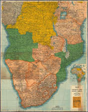
Carte du Cameroun, a French-language map produced in 1927, offers a detailed cartographic portrayal of Cameroon, delineating administrative boundaries, historical frontiers, and significant infrastructural elements. Highlighting the "Limite de Gouvernement ou de Colonie" and the "Ancienne Frontière Anglo-Allemande de la Nigéria", this map provides invaluable insight into the colonial divisions and historical contours that characterized Cameroon in the early 20th century.
In the 1920s, Cameroon was undergoing political and territorial realignments. Following World War I, the defeat of the Central Powers led to the partitioning of the former German Kamerun between France and Britain under League of Nations mandates. The "Ancienne Frontière Anglo-Allemande de la Nigéria" represents the erstwhile boundary between British Nigeria and German Kamerun, a poignant reminder of the colonial contestations that have played a role in shaping modern Africa.
The details of the map emphasize more than mere territorial claims; they highlight a changing landscape marked by infrastructural development. The notations of "Chemin de fer construit" and "Chemin de fer en construction" underscore the expansion of rail networks, while "Route Automobilisable", "Piste aménagée", and "Voie Decauville" indicate the varying levels of road infrastructure and transport pathways. These developments were integral to the colonial administration's endeavors to exploit and navigate the region's rich resources and vast terrains.
Furthermore, the distinctions between "Chef-lieu de Circonscription" and "Chef-lieu de Subdivision" offer a glimpse into the colonial administrative divisions, signifying the layered and hierarchical nature of governance. The map, thus, stands as both a testament to Cameroon's colonial legacy and an artifact documenting the era's infrastructural and administrative evolution.