


|
||

|

|
|

|
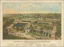
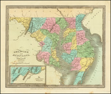
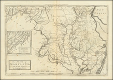
The Rand McNally New Commercial Atlas Map of Maryland and Delaware, published in 1912, offers a meticulous delineation of the railway and electric lines connecting the states of Maryland and Delaware, including specific details on various railroad companies and services. Featuring an inset of "Baltimore and Environs," the map provides not only geographic details but also a glimpse into the transportation infrastructure of the time, marked by the proliferation of both steam railroads and electric railway systems.
At the dawn of the 20th century, the regions of Maryland and Delaware were experiencing significant growth and transformation, aided in part by an expanding transportation network. Railways had become essential to the commercial and industrial life of the states, connecting cities and rural areas, facilitating the movement of goods, and opening new opportunities for travel and tourism. Electric lines, a relatively recent innovation, were also beginning to make their mark, heralding a new era of urban and suburban connectivity.
The map's detailed enumeration of railroads, such as the Baltimore & Ohio, Chesapeake & Ohio, Maryland & Pennsylvania, and others, speaks to the complex web of transportation that crisscrossed the two states. Different types of express services, denoted by "Ad. Exp." (advertised express) and "U.S. Exp." (United States express), reflect the varying levels of service and reach offered by these railroads. The distinction between steam and electric lines illustrates the technological diversity and innovation of the period.
The inclusion of the inset "Baltimore and Environs" underscores the significance of Baltimore as a major urban and transportation hub in the region. Its status as a vital seaport and commercial center made it a nexus of rail and shipping activity, mirrored in the map's specific attention to the city's railway connections.
Overall, the Rand McNally New Commercial Atlas Map of Maryland and Delaware serves as a document of historical and geographical significance. It captures the transportation landscape of the early 20th century, a time of technological innovation and expansion that shaped the social and economic fabric of Maryland and Delaware. The map stands as a testament to the era's ambitions and achievements, providing insights into a critical phase of American industrial and infrastructural development.
Rand McNally & Co. is a large American map and navigation company best known for its annual atlases. The company got its start in 1856, when William Rand opened a print shop in Chicago. He was joined in 1858 by a new employee, Andrew McNally. Together, the men established their namesake company in 1868. Originally, the company was intended to print the tickets and timetables for the trains running to and through Chicago; their first railway guide was published in 1869.
By 1870, they had shifted from just printing to publishing directories, travel guides, and newspapers. Their first map appeared in 1872 in a railway guide. The map was produced using a new wax engraving method, a cheaper process that gave the company an edge.
By 1880 Rand McNally had entered the education market with globes, wall maps, and geography texts for students. In 1923, Rand McNally published the first Goode’s World Atlas, named after its editor, Dr. J. Paul Goode. For generations afterward, this would be the standard classroom atlas.
In 1899, William Rand left the company, but McNally and his family remained, controlling the company for over a century. In 1904, they published their first road map intended for automobiles and by 1907 were publishing Photo-Auto Guides, which combined photography and mapping to help drivers. In 1924, they produced the Auto Chum, a precursor to their famous road atlases. Rand McNally would remain the leader in road maps and atlases throughout the twentieth century.
In 1937, Rand McNally opened its first store in New York City. Ever on the frontier of technology, Rand McNally pioneered the scribing process for printing tickets in 1958 and printed their first full-color road atlas in 1960. Arthur Robinson developed his now-famous projection of Rand McNally in 1969. By the 1980s, the company was exploring digital reproduction and digital databases of maps for truckers. In the 1990s, they lead the charge to develop trip-planning software and websites. Today, most of its products are available online or in a digital format, including maps for tablets and phones.

![[ Washington DC / Virginia / Maryland / Delaware / New Jersey ] Washington Sectional Aeronautical Chart](https://storage.googleapis.com/raremaps/img/small/99620.jpg)
![A General Atlas Containing Distinct Maps Of all the known Countries in the World. Constructed from the Latest Authority [Binder's title: Lucas's Cabinet Atlas]](https://storage.googleapis.com/raremaps/img/small/80266.jpg)