|
||

|

|
|

|
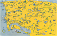
This plat of Pueblo Lot No. 1166 in the City of San Diego, California, surveyed on May 27th, 1890, by County Surveyor Harry Clangrehr, delineates a distinct piece of land on the east side of San Diego Bay. With an area of 60.00 acres, including 5 75/100ths acres for Railroad Right of Way, this survey specifically marks the entrance of Chollas Creek into the Bay of San Diego, a location now identified with the modern-day San Diego Naval Base.
The late 19th century was a significant era in San Diego's urban development. The emergence of railroad infrastructure, along with naval and maritime activities, contributed to the city's growth and transformation into a major port. The detailed description of the land, its boundaries, and its alignment with natural features like Chollas Creek provides insights into the surveying techniques and land management practices of the time.
The specific land of Pueblo Lot No. 1166 holds historical relevance for its connection to the larger urban landscape of San Diego. The inclusion of Railroad Right of Way indicates the integration of transportation networks, a key factor in the city's economic expansion. Moreover, its proximity to the Bay underscores the significance of maritime activities that later led to the establishment of the Naval Base.
The survey's notation of variations and meandering along the high tide level reveals the attentiveness to natural geography and water boundaries. Such precise documentation was essential in defining property rights, planning infrastructure, and managing land resources. The topographical relationship between Chollas Creek and the Bay further emphasizes the intricate interplay between human-made structures and natural landscapes.
Overall, the plat of Pueblo Lot No. 1166 presents a snapshot of San Diego's historical geography, contributing to the understanding of urban planning and land utilization in a rapidly evolving cityscape. Its alignment with the current Naval Base offers a tangible link between the past and the present, reflecting the enduring impact of surveying and land allocation on the shape and character of a dynamic urban environment.
![(San Diego) Map of the Water Front of San Diego on San Diego Bay Showing the Line of Mean High Tide [National City to Old Town] [with] Map of the Water Front of San Diego on San Diego Bay Showing the Line of Mean High Tide [Midway District to Point Loma]](https://storage.googleapis.com/raremaps/img/small/95403.jpg)