


|
||

|

|
|

|
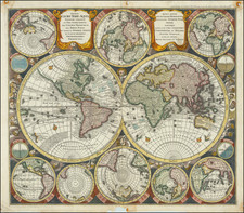
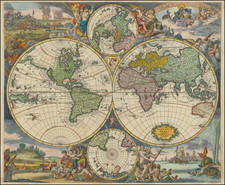
One of the Great Rarities of 17th-Century English World Maps.
A handsome original hand-color example of John Seller's map double hemisphere map of the world, which appeared in his Atlas Maritimus beginning about 1675.
Cartographically, the map follows the Dutch modes of the period, with some toponymy changed out for English preferences. The map features California as an Island, emerging coastlines of Australia and New Zealand, and allusions to discoveries and English settlements in North America ("New Pleymouth", "Maryland", "Virginia", etc.).
The Decorative Embellishments
It is worth examining the decorative elements of this map, which break from previous English traditions and are well engraved and compositionally successful.
The scenes directly above and below the hemispheres must have been influenced by Nicholas Van Geelkercken's unusual 1617 world map, titled Orbis Terrarum Descriptio Duobis Planis Hemisphaeriis Comprehe[n]sa. Here, Seller has reinterpreted Van Geelkercken's allegories of the seasons, with the lower left featuring Bachus and winemaking, albeit with a somewhat more refined engraver's hand.
Representations of celestial bodies dominate the borders, with two depictions of the moon, one "naturalis" and one "artificial," as first published by Hevelius in 1647. Seller also includes popular comparative celestial mechanics, so much the rave in the 1660s and '70s, with an earth-centered planetary system following Ptolemy, a sun-centered system after Copernicus, and the hybrid system according to Tycho Brahe.
The four elements are embodied in animals: a dragon for fire, rabbits for earth, an eagle for air, and a sea monster for water. Representations of the twelve Zodiac signs are also included.
Overall, the effect is striking and merited inclusion at the beginning of Shirley's The Mapping of the World as one of the book's few color illustrations.
States
There are four states (Shirley alludes to 3); however, the first two of these are essentially pre-publication proofs of varying levels of completeness.
This is the first completed state.
In 1702, the map was altered to remove Seller's name, resulting in the final state.
John Seller was one of the most notable map and instrument makers in England in the late-seventeenth century. He was especially known for the sea charts, many of which featured in his influential English Pilot and Atlas Maritimus. Seller was born in London in 1632. His father was a cordwainer and John was apprenticed to Edward Lowe, of the Merchant Taylors’ Company. He was made free of that company in 1654. Later, he also was made a brother of the Clockmakers’ Company, which housed several instrument makers. He started business as a compass maker but expanded his offering to include navigational instruments and charts.
Seller’s career was halted temporarily, and fantastically, when he was tried for high treason in 1662. He was accused of involvement in a plot led by Thomas Tonge. While Seller likely only unwisely repeated rumors, he was convicted. The other conspirators, who did admit some degree of guilt, were executed, but Seller maintained his innocence and, via insistent petitions, he eventually secured his release from Newgate Prison.
This episode did not seem to slow Seller’s rise too much, however. Seller was granted a royal license to publish English-language maritime atlases. This gave him a near-monopoly and led to his being named hydrographer to the King in 1671. Although the point of the project was to produce English charts of Dutch dominance and bias, Seller ended up using many Dutch plates as his base material. The first volume of The English Pilot was published in 1671, followed by more volumes as well as The Coating Pilot (1672) and the Atlas Maritimus (1675). Seller was commercially successful, but some of his projects required further support. The English Pilot was eventually taken over by John Thornton and William Fisher, for example, and his proposed English atlas only produced maps of six counties.
Seller’s sons, John and Jeremiah, followed in their father’s profession. Seller also apprenticed several promising young men, including Charles Price, with whom his sons partnered. Through Price, Seller can be seen as the founding figure of an important group of London mapmakers that included Price, John Senex, Emanuel Bowen, Thomas Kitchin, and Thomas Jefferys.
![[ World ] Air France -- Sur Les Ailes D'Air France Decouvrez Le Monde A Votre Tour](https://storage.googleapis.com/raremaps/img/small/100053.jpg)
![[ World Atlas ] [ Composite Atlas of the World including important American maps and Whiston's Scheme of the Solar System ]](https://storage.googleapis.com/raremaps/img/small/100165.jpg)