


|
||

|

|
|

|
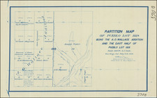
Image of Planning for The Sweetwater Dam.
Detailed depiction of the eastern portion of a reservoir on the upper part of the Sweetwater River South San Diego County, a portion of Today's Sweetwater dam. The map would seem to be a planning map, overlaying the projected location of the northeastern part of the Reservoir which would be created by the Sweetwater Dam on a portion of the former Jamaca Rancho.
Of particular note is a cabin on the Sweetwater River, which would have been lost to the flooding of the area, as well a the location of the Road and Springs on the map.
The map in question identifies Lot G, the Lot created in 1881 at the time of final confirmation of the partition of the original Rancho Jamacha to its then-current owners.
The history of the Jamacha Rancho's dates back to the early 19th century, illuminates a crucial facet of San Diego's socio-economic evolution. Known as "Rancho Jamacha," the 8,881-acre Mexican land grant in present-day San Diego County was conferred by Governor Juan Alvarado in 1840 to Apolinaria Lorenzana, a single woman who came to the San Diego Mission at age 12 and became a beloved figure in the last days of the Mission, before it was abandoned in the 1840s. The Rancho stretched eastward from Rancho de la Nación, encompassing parts of La Presa, Spring Valley, Lemon Grove, Encanto, and Jamacha, with the Sweetwater River providing its vital water source. The name "Jamacha," derived from indigenous roots, became synonymous with the land.
The land in question would become part of the Monte Vista Ranch. At the time of the partition of the land in March 1881, the land was owned by Mrs. E.A. Pendleton, to whom the court conferred the original "Plat G", consisting of approximately 1890. The court, after investigating the legitimacy of the various claims, ordered that the rancho be surveyed and subdivided into nine parcels designated Plats A through I were surveyed. Plats A through F were in the Jamacha Valley, with Plat G being at the southwestern most part of the Rancho. Over the course of the next decade, the land changes hands several times.
The Reservoir shown on the map is today's Sweetwater Dam, a significant development in the area's water infrastructure. The need for a steady and reliable water source in the arid climate of Southern California led to its construction. First suggested by Frank Kimball in 1869, it was not until the land was acquired by the San Diego Land & Town Company that the project came to fruition. Work on the dam began in November 1886 and was completed by March 1888, under the supervision of James D. Schuyler, a prominent civil engineer of the era.
The dam and the lands used for the reservoir site cost approximately $234,000, which was a substantial investment in the late 19th century. The entire system of distribution exceeded half a million dollars. Once completed, the reservoir had a capacity of 7 billion gallons, which provided a crucial water supply for several communities in the area, including National City, Chula Vista, and parts of Sweetwater Valley.
The Otay Water Company, founded in March 1886 with E. S. Babcock as the principal owner, was initially focused on irrigating the Otay Valley lands and the adjacent mesa. In 1895, Babcock sold a half-interest to the Spreckels brothers, who were prominent figures in the local business community, and the company was renamed the Southern California Mountain Water Company.
The Spreckels brothers eventually became the sole owners of the company, furthering its expansion and influence in the region. The company undertook a major project in the early 20th century to supply the entire water supply to the city of San Diego. It built a storage dam at Moreno and extended its pipeline to the city's reservoir, which began delivering water in the summer of 1906.
This series of developments, including the construction and operation of the Sweetwater Dam, were pivotal moments in San Diego's history, shaping the growth and development of the region. They illustrate the significant role of water management in the American West, an area often prone to droughts and water shortages. The Sweetwater Dam, along with the other water infrastructure developed during this era, paved the way for the sustained growth and expansion of these southern California communities.
The San Diego Land & Town Company
The San Diego Land & Town Company was initially set up in 1880 to sell land to finance the California Southern Railroad, a thwarted attempt to make San Diego a Pacific terminus of a transcontinental railroad. Despite California Southern's failure to directly link San Diego to the East Coast, the well-financed Boston-based syndicate that controlled the SDL&T Co. shaped the company into a major force during San Diego's 1880s land boom.
![[ Earliest Obtainable Map of San Diego Bay ] Plan du Port De St. Diego en Californie. . . 1782 [with] Plan Du Port et du Departement de San Blas . . . 1777](https://storage.googleapis.com/raremaps/img/small/90982.jpg)
![[ La Jolla ] La Jolla Street Map](https://storage.googleapis.com/raremaps/img/small/100138.jpg)