


|
||

|

|
|

|
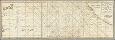
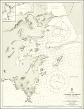
Scarce early map of the Baja Peninsula, from San Diego to Cabo San Lucas, along with the Gulf of California, extending Valle de Banderas Bay.
This 19th Century map of Baja California by Augustus Petermann is an intriguing historical artifact that chronicles a slice of North American geography with impressive precision and details. The map displays the Baja Peninsula in its entirety, extending from San Diego in the north to Cabo San Lucas at the southern tip. The Gulf of California, also known as the Sea of Cortez, is represented in its full stretch, with the coast of mainland Mexico extending south as far as the Valle de Banderas Bay.
The scarcity of such early maps of Baja California adds to its uniqueness and historical significance. The coastal details are painstakingly rendered, reflecting a deep understanding of the topography, while the interior is still little known or explored.
This map is a reworking of Commander George Dewey's original survey. Dewey, later known as Admiral Dewey, led Pacific Coast Survey explorations between 1873 and 1875 while aboard the U.S.S. Narragansett, which had now been assigned to survey the Pacific Coast of Mexico and Lower California. This tedious duty in the blazing heat and virtual isolation of the Gulf of California was relieved only by occasional visits to the port of La Paz to refuel and collate data. .
August Heinrich Petermann (1822-1878) is a renowned German cartographer of the nineteenth century. Petermann studied cartography at the Geographical Art-School in Potsdam before traveling to Edinburgh to work with Dr. A. Keith Johnston on an English edition of Berghaus’ Physical Atlas. Two years later he moved to London, where he made maps and advised exploratory expeditions as they set off to explore the interior of Africa and the Arctic.
In 1854, Petermann returned to Germany to be Director of the Geographical Institute of Justus Perthes in Gotha. There, he was the editor of the Geographische Mittheilungen and Stieler’s Handatlas. The Royal Geographical Society of London awarded him their Gold Medal in 1860. He continued his interest in exploration in Germany, fundraising for the German Exploring Expeditions of 1868 and 1869-70, which sought an open Arctic sea. Tragically, he committed suicide in 1878.
![[Baja California, Gulf of California and Sonora] Amer. Sep. No. 58 Partie De La Vieille Californie](https://storage.googleapis.com/raremaps/img/small/62785.jpg)