


|
||

|

|
|

|
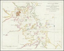
Detailed map of Cape Cod and its surrounding area as of 1917, produced by the Walker Lithographic and Publishing Company.
The map covers the stretch from New Bedford to the Atlantic Ocean and from Whitman and Provincetown down to Nantucket. Designed for navigational use, the map features prominently marked 'best routes' indicated by solid red lines, alongside a network of other roads, with some identified by name.
The map is detailed, labeling numerous towns and cities including Hyannisport, Yarmouth, W. Yarmouth, Prospect Hill, and Provincetown. Counties within the region are easily distinguishable through the use of bold lettering and thick beige boundary lines. Notable geographical features such as Buzzards Bay and Cape Cod Bay, along with various bays, points, and other coastal features are also meticulously identified.
Included within the scope of this map are Martha's Vineyard and Nantucket, both detailed with precision.
![[ Revolutionary War Boston ] Carte Particuliere Du Havre De Boston . . . 1780](https://storage.googleapis.com/raremaps/img/small/61227.jpg)

![[Special Promotional / Sample Map for Rand McNally Business Atlas] Massachusetts](https://storage.googleapis.com/raremaps/img/small/89042.jpg)