|
||

|

|
|

|
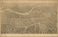
Decorative map of London, with vignettes showing major landmarks around the map and various pictorial representations of major landmarks within the map.
The first map is a map of London produced in the mid-1920s by G.W. Bacon & Company. The map is centered on the city from Tower Bridge to Hammersmith Bridge and extends northwards to Regent's Park. Its primary feature is the delineation of a suggested tourist itinerary, highlighted in red, with further details provided in the accompanying Sightseer’s Guide, which is affixed to the map's front cover.
The designation "picture map" is derived from the numerous illustrations adorning the map, depicting prominent buildings and points of interest throughout central London and along its periphery. The illustrations serve both as a navigational aid and as an invitation to explore the architectural and historical richness of the city.
In the map's lower corners, indices list the locations of theaters, music halls, hotels, principal attractions, and significant commercial entities, aiding visitors and residents alike in navigating London's cultural and commercial offerings. Transportation routes are marked, prioritizing main thoroughfares, while secondary roads are less emphasized. Accompanying the visual details, the map provides a comprehensive street index, facilitating the location of specific addresses and sites.
The accompanying piece, The Way to Wembley, specifically caters to visitors of the British Empire Exhibition of 1924. It outlines the principal routes from central London to the exhibition grounds, detailing public transportation options including train, bus, and tram services. This map was instrumental during the event, guiding countless visitors through London's transport network to the exhibition, a focal point for cultural and economic display during the period.
These maps, beyond their immediate utility, serve as historical documents. They capture London at a specific time, reflecting the city's urban landscape, transportation infrastructure, and the cultural priorities of the era. For scholars and enthusiasts of cartography and urban history, these artifacts provide insight into London's development and the societal trends of the early twentieth century. They hold particular value for their detailed representation of the city's geography and infrastructure, set against the backdrop of post-World War I reconstruction and the British Empire Exhibition, a significant event in the city's, and the empire's, history.
![[London] Redriffe and Part of St. Mary Magdalens Parish Southwark Taken from ye Latest Survey with Corrections](https://storage.googleapis.com/raremaps/img/small/70290.jpg)