|
||

|

|
|

|
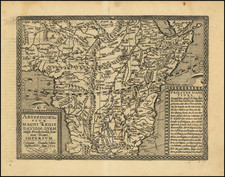
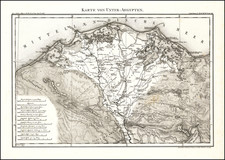
Searching for the Source of the Nile -- The Map Which Launched Giovanni Miani's Exploration Career
Rare and finely detailed map of the Nile Basin showing the origin of the Nile River and the "Rivers of Zanzibar," prepared by Giovanni Miani, which would launch his career as an explorer of the interior parts of Africa. With this map, he would propose his ambitious projects for further exploration.
Miani would go on to become one of the most important mid-19th Century explorers, who greatly furthered the exploration and mapping of the search for the source of the Nile. The map covers the region from the Mediterranean coastline of Egypt and the Red Sea to Lac Zaire (Lake Victoria), with a small inset map of Africa.
The present map is Miani's watershed moment, converting him from a little known amateur explorer to prominence. In 1857, after several years of exploration, he visited Upper Nubia, and drew the present map of the region based on his own observations and the accounts of sailors, merchants, hunters and missionaries. He had the map printed in Paris in 1858 and presented a copy to Napoleon III, along with his project for exploring the Nile basin to find the river's source.
The map's note at the bottom right provides a marvelous overview:
Information for a Future Expedition to the Sources of the Nile
We have prepared this Map with the aim of facilitating research on the grand question of the sources of the Nile. It is the culmination of ten years of study and travel in Egypt, the insights we have garnered from Mr. Figari Bey and other learned explorers, as well as the accounts of the most recent travelers. It offers a plethora of useful knowledge regarding agricultural zones, climatic boundaries, and historical facts, thereby we believe it will present some interest to enlightened travelers.
For a long time, we have harbored the project of seeking the origin of the Nile by the shortest route; however, various circumstances have yet to allow us to realize it. The missionaries Krapf Rebmann and Erhardt, who explored parts of the Languebar coast, did not consider ascending the Melinde River, which is a hundred leagues from the Equator.
We believe that to reach the area presumed to contain the sources of the Nile, one would need to ascend this river, cross the Gebel Kénia and its volcano, search for the lake of Gebel-Regief, reach the Equator, and before arriving at Gebel-Kambirat, near the kingdom of Robenga, one should find the origin of the Nile. By following its course, the explorer would arrive at Bellena where the Austrian missionaries from Khartoum have established a presence.
After recognizing the equatorial line, the expedition should verify the existence of metal mines and precious stones. Boats manned by trustworthy individuals would depart from Egypt in August, head to Khartoum to take on interpreters, and ascend the White Nile in October to reach Bellena. From there, with the influence of the missionaries, armed men with faithful Berri would be sent to meet the expedition coming from the Indian Ocean via one of the Languebar rivers at the same time. This junction at Robenga would enable a journey to Bellona, and from there, the boats would descend the river exploring the Sobat, No and Fitri lakes, trading ivory from the local inhabitants for beads and other goods stocked on the boats. According to the information we have received, boats cannot surpass the 5th degree of latitude even during the high water season, because after the rains, the Nile dries up and is only fed by its numerous tributaries. The decomposed waters that run through the marshes, pushed by the new periodic rains, are then carried in June to the sea, are greenish and of poor quality; it is before this time that these marshes cause deadly fevers in Sennar.
We have observed in February a multitude of clouds moving from the Mediterranean towards the Equator to turn into torrential rains, melting the snow and ice of the high mountains to increase the volume of water in this river, causing the phenomenon of its periodic flood.
As for the existence of large lakes under the Equator, it has been confirmed by the latest travelers, and we provide on this map, with a dotted line, the route that led the Berri to the Ocean, where they saw our steamships and described them in a very picturesque language.
These Berri saw in the lake of Gebel Regief, after the equatorial rainy season, the waters taking two directions, one towards the north to form the White Nile, and the other towards the south, giving birth to the rivers of Languebar. It is thus in the region of earthquakes that one must seek the origin of the Nile. The account of the Berri perfectly matches the map of Africa by Juan de la Cova, of which we provide a sketch. Moreover, only through the communication of Lake Regief with both slopes 1º of the Nile, 2º of the southern rivers that flow into the Ocean, can one explain the presence in the Nile of certain fish that have the property of inflating at will, and whose species is unique to the Red Sea. We thus believe that an expedition directed according to the plan we propose would offer execution facilities: one would not have deserts to cross, but rivers to ascend.
In addition to the great scientific interest attached to its realization, commercial interest would also be joined by the products that could be obtained along the way from trade and the great hunt for elephants, rhinoceroses, and hippopotamuses. The expedition should consist of ten scientists of different specialties, with 50 armed men accustomed to hardships. It should have a very complete set of equipment, then despite the unfortunately unsuccessful efforts of the Egyptian Government and its too often tested liberality. H.E. the Viceroy, whose enlightened spirit understands the full importance of such a discovery, seeing determined men with means, would deign to grant them his generous protection.
Rarity
The map is very rare.
OCLC locates 4 copies (Biblotheque National de France, Damstadt University, University of Leiden and Library of Congress (Hauslab-Liechtenstein collection).
OCLC also locate a single 1862 example (British Library)
Giovanni Miani (1810–1872) was an Italian explorer whose work primarily focused on the exploration of the Nile and the region around the Uele River in present-day Democratic Republic of the Congo. Born on March 17, 1810, in Rovigo, Veneto, Italy, Miani embarked on a series of explorations that positioned him as a notable figure in the quest to identify the Nile's source.
Miani was born to Maddalena Miani, with his father's identity remaining unknown. His early education was sponsored by P. A. Bragadin, offering him a broad foundation in music, science, and languages. Following the death of his benefactor in 1828, Miani inherited a significant estate, which later financed his initial explorations. His mother's death in 1837 marked a turning point, leading Miani to devote his life to music and subsequently to exploration.
After fighting with Garibaldia during the Risorgimento, Miani fell out of favor and left Italy, moving to Istanbul, where he continued his career as a musician. After traveling in Egypt and Palestine, he learned Arabic and became interested in further exploration of the interior of Africa. In 1857 he visited Upper Nubia with two young Frenchmen, and drew a map of the region based on his own observations and the accounts of sailors, merchants, hunters and missionaries. He had the map printed in Paris in 1858 and presented a copy to Napoleon III, along with his project for exploring the Nile basin to find the river's source. He was admitted to the Société de Géographie of Paris.
Miani's notable expedition to the Nile began in 1859, supported by the Egyptian government and the Société de Géographie. On May 10, 1859, he departed Cairo, reaching Omdurman on July 20. Miani's journey took him to Sennar between September 20 and November 7, 1859, alongside a diverse team that included a navy captain and an Arabic-French translator.
On December 5, 1859, Miani advanced southward from Khartoum, engaging with Andrea Debono's company. Despite encountering resistance and hardships, he reached Gondokoro on January 24, 1860, a significant milestone in his journey. His attempt to navigate beyond the Makedo Falls was hindered by poor health and logistical challenges, forcing a return to Gondokoro.
Miani's exploration reached a critical point on March 29, 1860, when he ventured south, nearing the source of the Nile at a latitude of 3°32'N. Despite the proximity, hostile conditions and the refusal of his escort to proceed further compelled Miani to retreat.
Miani continued his explorations upon returning to Khartoum on May 22, 1860. His subsequent travels included ventures into the regions around the Uele River, marking him as one of the first Europeans to document this area.
Miani's third Nile expedition in 1871–1872 aimed to explore the Mangbetu region. Despite deteriorating health, he embarked on this journey, traversing challenging terrains and engaging with local tribes. His exploration provided detailed accounts of the regions and peoples encountered, contributing to the broader understanding of central African geography and cultures.
Miani's explorations, despite not achieving the goal of locating the Nile's source, added significant knowledge to the mapping and understanding of the Nile and central African regions. His detailed observations, maps, and collections of artifacts enriched European knowledge of Africa during a period of intense exploration interest.