|
||

|

|
|

|
Stock# 96169
Description
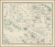
World War II-era chart in 1:3,000,000 scale of the southwestern Pacific Ocean, showing Fiji, the Gilbert Islands, Wallis and Futuna, Tuvalu, the Samoan Islands, Canton Island, Niue, and other atolls in the vicinity. Many island airstrips built and used for the United States' "leapfrogging" strategy against the Empire of Japan are on the map with their radio station call letters.
Condition Description
Minimal soiling and toning near edges; minimal fold toning.
![[ Australia & New Zealand ] La Nuova Guinea e Nuova Galles](https://storage.googleapis.com/raremaps/img/small/86442.jpg)
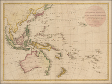
![[ Australia called Notasie ou Nouvelle Hollande ] Carte De L'Oceanie Contenant L'Australe, La Polynesie et Les Iles Asiatique . . . 1838](https://storage.googleapis.com/raremaps/img/small/99649.jpg)
![(Second World War - Berghof) Karte des Berghofgeländes Map of the Berghof-area [with:] Karte des Berghofbunkers Map of the Berghofbunker](https://storage.googleapis.com/raremaps/img/small/100680.jpg)