|
||

|

|
|

|
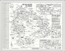
Fantastic complete set of early 1940s topographical maps of the Big Island of Hawaii, forming a gargantuan wall map of the island.
The nearly ten-foot-tall map shows the iconic shape of the island in great detail. Topography, lava fields, river systems, and other features of natural geography are all shown. Hilo is mapped with individual buildings shown, and roads and other features all shown. Each sheet shows an area that covers approximately one hundred square miles, testifying to the impressive scale of the map.
The map is based on an initial survey by Bishop Moorhead in 1921, controlled by the Hawaiian Territorial Survey. These sheets were from the 1924 edition but were printed between 1942 and 1943.
The composite map is composed of the following quadrangles:
- Kohala
- Waipo
- Hamakua
- Keahole
- Puako
- Waikii
- Mauna Kea
- Honomu
- Kailua
- Kaohe
- Humuula
- Hilo
- Makuu
- Honaunau
- Mauna Loa
- Kilauhea
- Puna
- Kalapana
- Hoopulau
- Honaupo
- Pahala
- Kalea
![[ Kealakekua Bay, Hawaii ] Village de Kearakekoua. Iles Sandwich](https://storage.googleapis.com/raremaps/img/small/99764.jpg)
![[The Big Island] Hawaii Hawaiian Islands . . . / The Island of Hawaii](https://storage.googleapis.com/raremaps/img/small/83460.jpg)
![[Early Hand Drawn Map of the Hawaiian Islands]](https://storage.googleapis.com/raremaps/img/small/62429.jpg)