|
||

|

|
|

|
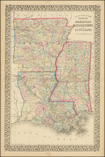
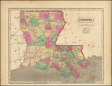
Louisiana by David Hugh Burr, engraved by Illman & Co. and published in Brattleboro, Vermont in 1834, presents an early and detailed depiction of the state during its nascent stages of development. With a conspicuous representation of its primitive parish system, especially in the northern and western sectors, this map showcases seven dominant parishes ruling vast expanses of the region.
The 1830s were a crucial period in the historical trajectory of Louisiana. The state, having joined the Union in 1812, was in the midst of demarcating its administrative boundaries, leading to the establishment of its distinct parish system. This system was pivotal for governance, as parishes played a central role in local administration and community organization, mirroring counties in other American states. The delineation of so few parishes in the expansive northern and western territories of Louisiana underscores the fledgling nature of administrative establishment in these areas.
Burr's portrayal of the roadways is another testament to the state's budding infrastructural progression. Sparse roads are plotted, with very few connecting the northern and southern extremities, indicating the challenges of connectivity and the vast untouched terrains. The preeminence of indigenous territories and prairies in the north and west stands as a chronicle of the times, shedding light on the enduring presence of Native American communities and their dominance in certain locales.
The engraving work by Illman & Co. captures the geographical nuances of Louisiana, encapsulating its topographical variances and shedding light on the state's evolving landscape. This map, while charting physical terrains, also acts as a historical document, echoing the socio-political nuances and the territorial complexities of Louisiana during the 1830s.
David H. Burr studied law, passing the New York Bar Exam, and then surveying under Simeon DeWitt in New York. His first atlas was an atlas of New York State (1829), the second state atlas to be issued in the US (after Mills’ Atlas of South Carolina in 1826). In the 1830s, he served as the official topographer for the US Post Office, producing a series of rare and highly sought-after large-format state maps. He also created a map of the country’s postal routes, which features roads, canals, and railroads. Burr traveled to London to work with John Arrowsmith; together, they produced the American Atlas in 1839.
Upon his return to the States, Burr was appointed as a draftsman for the House of Representatives, where he worked until ca. 1841. He later worked for the Louisiana Survey and the Florida Survey. By 1850, he was back in Washington D. C., working on the census. In 1852, the Senate named Burr as the draftsman to compile maps from the Federal Surveys. In 1853, Burr traveled to San Francisco, perhaps as part of his work for the Senate. He was then named as the Surveyor General of Utah in 1855. However, he was unpopular there and returned to Washington D. C. by 1870. Burr is widely regarded as one of the most important names in the nineteenth-century American history of cartography.
![[Florida and Gulf Coast] The Coast of West Florida and Louisiana . . . [with] The Peninsula and Gulf of Florida or Channel of Bahama with the Bahama Islands . . .](https://storage.googleapis.com/raremaps/img/small/66344.jpg)