


|
||

|

|
|

|
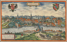
Colonia Agrippina by Braun & Hogenberg, dated circa 1572, offers a detailed bird's-eye view of the city of Cologne, combining architectural detail, urban planning, and historical commentaries. Within the map, the well-defined semicircular ground plan of Cologne fronting the Rhine is brought to life, capturing the city's vast expanse and its defining landmarks, most notably the towering Cologne Cathedral and the artistically described town hall.
The Late Renaissance era, within which this map was conceived, was a period characterized by the fusion of artistic grandeur and empirical observation. As Europe ventured deeper into the Age of Exploration, maps of cities such as Cologne became not only navigational aids but also artistic and historical testaments of the time. At this juncture, Cologne was experiencing a phase of economic and cultural flourishing, notably its close trading ties with England, and the establishment of the Cologne exchange in 1553. The presence of a bustling population, represented by the intricately illustrated buildings and streets, reflected its prominence as an epicenter of trade, academia, and faith.
The narrative inscribed within the cartouches provides a depth of historical context. The top cartouche, which chronicles the transformation of Divitense Munimentum, sheds light on Cologne's strategic importance from Roman times, emphasizing its function as a protective fortress against potential invasions. On the other hand, the bottom left cartouche delves into the significance of Cologne's bridge, an emblem of sovereignty and defense, and the symbolism behind the city's insignia, linking it to the religious import of the relics of the Magi. Additionally, the bottom right cartouche portrays Cologne as a beacon of political and ecclesiastical power in Germany, highlighting its influential roles within the Hanseatic League and the Holy Roman Empire.
Furthermore, Braun's commentary provides an intimate perspective, painting a vivid portrait of Cologne as a dynamic city proud of its monumental structures. Particular attention is drawn to the cathedral, a masterstroke of Gothic architecture and a testament to the city's religious fervor. Equally, the depiction of the town hall emphasizes the city's civic pride and its standing as a hub of governance.
Braun & Hogenberg's depiction of Cologne stands not just as a geographical representation, but as a tapestry weaving together the city's architectural, political, and spiritual fabric during a significant epoch of its history.
Georg Braun (1541-1622) was born and died in Cologne. His primary vocation was as Catholic cleric; he spent thirty-seven years as canon and dean at the church St. Maria ad Gradus, in Cologne. Braun was the chief editor of the Civitates orbis terrarum, the greatest book of town views ever published. His job entailed hiring artists, acquiring source material for the maps and views, and writing the text. In this role, he was assisted by Abraham Ortelius. Braun lived into his 80s, and he was the only member of the original team to witness the publication of the sixth volume in 1617.
Frans Hogenberg (ca. 1540-ca. 1590) was a Flemish and German engraver and mapmaker who also painted. He was born in Mechelen, south of Antwerp, the son of wood engraver and etcher Nicolas Hogenberg. Together with his father, brother (Remigius), uncle, and cousins, Frans was one member of a prominent artistic family in the Netherlands.
During the 1550s, Frans worked in Antwerp with the famous mapmaker Abraham Ortelius. There, he engraved the maps for Ortelius’ groundbreaking first atlas, published in Antwerp in 1570, along with Johannes van Deotecum and Ambrosius and Ferdinand Arsenius. It is suspected he engraved the title page as well. Later, Ortelius supported Hogenberg with information for a different project, the Civitates orbis terrarium (edited by Georg Braun, engraved by Hogenberg, published in six volumes, Cologne, 1572-1617). Hogenberg engraved the majority of the work’s 546 prospects and views.
It is possible that Frans spent some time in England while fleeing from religious persecution, but he was living and working in Cologne by 1580. That is the city where he died around 1590. In addition to his maps, he is known for his historical allegories and portraits. His brother, Remigius, also went on to some fame as an engraver, and he died around the same time as his brother.
![Ducatus Saxoniae Superioris prout ipsius conditio fuit ab Anno 1000 usque ad A. 1400 sive intra Seculum Xm. et XVm. ex historia maxime mediae aetatis erutus, ac Geographice designatus per [F]rid. Zollmann...](https://storage.googleapis.com/raremaps/img/small/71443.jpg)
![Heidelberga [and] Spira [and] Wormatia](https://storage.googleapis.com/raremaps/img/small/98992.jpg)
![Hennebergensis Ditionis vera delineatio . . . 1594 [and] Hassiae Descriptio . . .](https://storage.googleapis.com/raremaps/img/small/83926.jpg)