|
||

|

|
|

|
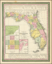
First Edition of Sanson's Map of Florida and the Southern parts of North America
Striking example of Sanson's important early map of Florida and the Southeast, illustrating a number of early and important cartographic features.
The first atlas map to correctly name Lake Erie, although it is pushed 2.5 degrees too far south, increasing the claims of France. Several new rivers appear in Virginia. The Caroline depicted on the map is Ft. Caroline, not the Carolinas.
The projection of the Southeast is improved over Sanson's folio map of the prior year. The Florida nomenclature is corrected from Sanson's North America map. Most of the rest of the map is Chaves/Ortelius nomenclature. The Southwest is still largely unknown.
This is the first edition of the map, bearing the date of 1657.
Lake Apalache
Lake Apalache, shown here in the Carolinas, stands as a symbol of the myths and challenges that early European explorers faced in charting the New World. Its tale weaves a fabric of ambition, indigenous interactions, and the evolving science of cartography.
The narrative of Lake Apalache can be traced back to the 16th century, as Spanish explorers embarked on journeys to uncharted territories. The name "Apalache" is likely a nod to the Apalachee, a Native American tribe in northwestern Florida. It was an era where cartographic knowledge was heavily reliant on oral accounts, leading to a blend of factual observations with imaginative speculations.
One significant figure in this tale is the Spanish explorer Hernando de Soto. In the 1530s, motivated by tales of a vast inland water body, de Soto ventured in search of Lake Apalache. Instead, he stumbled upon Anhaica, the primary settlement of the Apalachee tribe. Despite the absence of a grand lake, de Soto's explorations contributed valuable knowledge to the European understanding of the region.
As the quest for Lake Apalache continued, mapmakers like Jacques le Moyne and Gerardus Mercator incorporated this mythical lake into their works. Le Moyne's maps, influenced by tales from survivors of the ill-fated French colony of Fort Caroline, depicted a vast freshwater source, fueling further European interest. Mercator, a prominent geographer and cartographer, included Lake Apalache in his influential world map of 1569.
However, as the years progressed and more explorers surveyed Florida, the inaccuracies began to surface. The mythical representation of Lake Apalache gradually was pushed further north and ultimately vanished from maps by the 18th century, giving way to a more accurate portrayal of the region's geography.
Nicholas Sanson (1600-1667) is considered the father of French cartography in its golden age from the mid-seventeenth century to the mid-eighteenth. Over the course of his career he produced over 300 maps; they are known for their clean style and extensive research. Sanson was largely responsible for beginning the shift of cartographic production and excellence from Amsterdam to Paris in the later-seventeenth century.
Sanson was born in Abbeville in Picardy. He made his first map at age twenty, a wall map of ancient Gaul. Upon moving to Paris, he gained the attention of Cardinal Richelieu, who made an introduction of Sanson to King Louis XIII. This led to Sanson's tutoring of the king and the granting of the title ingenieur-geographe du roi.
His success can be chalked up to his geographic and research skills, but also to his partnership with Pierre Mariette. Early in his career, Sanson worked primarily with the publisher Melchior Tavernier. Mariette purchased Tavernier’s business in 1644. Sanson worked with Mariette until 1657, when the latter died. Mariette’s son, also Pierre, helped to publish the Cartes générales de toutes les parties du monde (1658), Sanson' atlas and the first French world atlas.