|
||

|

|
|

|
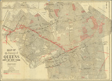
Rare separately published wall map of the environs of New York City, published by Rand McNally & Company.
The map is massive transit oriented map, focused the railroad, subways and elevated trains, steam railroads and ferries in the metropolitan area. The map extends north to New Rochelle and Yonkers, west to Far Rockaway, and south to Staten Island, with large inset maps of Lower Manhattan and Richmond.
In the early 20th century, New York's transportation network was vast, with multiple companies operating different lines. This key from the 1915 map provides a snapshot of the city's diverse transit options, reflecting the bustling nature of the metropolis.
- SUBWAY LINES I.R.T.: Subway routes operated by the Interborough Rapid Transit Company.
- SUBWAY LINES B.R.T.: Subway routes operated by the Brooklyn Rapid Transit Company.
- ELEVATED LINES I.R.T.: Elevated train routes operated by the Interborough Rapid Transit Company.
- ELEVATED LINES B.R.T.: Elevated train routes operated by the Brooklyn Rapid Transit Company.
- JOINT OPERATION I.R.T. SUB & EL: Indicates routes or areas where both the subway and elevated train services of the Interborough Rapid Transit Company operate jointly.
- JOINT OPERATION B.R.T. SUB & EL: Indicates routes or areas where both the subway and elevated train services of the Brooklyn Rapid Transit Company operate jointly.
- STEAM RAILROADS: Denotes routes or areas serviced by traditional steam-powered railroads.
- SURFACE LINES: Refers to street-level rail or trolley services.
- FERRIES: Indicates routes or docking areas for ferry services.
- TRACKLESS TROLLEYS: Refers to trolley cars that run on the road but are powered by overhead electric lines.
- HUDSON & MANHATTAN TUBES: Subway routes connecting New York and New Jersey, operated by the Hudson & Manhattan Railroad Company.
- JOINT OPERATION I.R.T. SUB & EL. WITH B.R.T. SUB.: Indicates routes or areas where both the Interborough Rapid Transit Company and Brooklyn Rapid Transit Company subway and elevated services operate in conjunction.
The story of New York City's subway system began in the late 19th century, when rapid urbanization and the city's geographic expansion underscored the need for a comprehensive mass transit solution.
-
Initial Proposals and the First Line (1870s-1904): In the 1870s, the idea of an underground transit system was proposed to alleviate the congestion on New York's streets. However, it wasn't until 1900 that construction of the first line commenced. This inaugural line was sponsored by the Interborough Rapid Transit Company (I.R.T.). On October 27, 1904, the first official subway line opened to the public, stretching from City Hall in lower Manhattan to 145th Street in Harlem.
-
Expansion and Integration (1905-1913): Following the immediate success of the first line, there was a surge in efforts to expand the subway system. The I.R.T. soon extended its operations, reaching Brooklyn by 1908. Meanwhile, the Brooklyn Rapid Transit Company (B.R.T.), another significant player, began developing its own subway lines, ensuring a more comprehensive reach of the system across the boroughs.
-
Dual Contracts (1913-1920): Recognizing the growing demand for subway services, the city brokered the "Dual Contracts" in 1913. This historic agreement facilitated the expansion of both the I.R.T. and the B.R.T., essentially doubling the city's subway infrastructure. Under this contract, many of the city's most iconic lines and stations were constructed. The reach of the subway now extended deep into the Bronx, Brooklyn, and Queens.
Rarity
The map is very rare.
We were unable to locate any pre-1920 examples of this map in OCLC. The only pre-1925 example in OCLC is a 1922 edition, located in a single example at the University of Wisconsin Milwaukee (American Geographical Society collection).
Rand McNally & Co. is a large American map and navigation company best known for its annual atlases. The company got its start in 1856, when William Rand opened a print shop in Chicago. He was joined in 1858 by a new employee, Andrew McNally. Together, the men established their namesake company in 1868. Originally, the company was intended to print the tickets and timetables for the trains running to and through Chicago; their first railway guide was published in 1869.
By 1870, they had shifted from just printing to publishing directories, travel guides, and newspapers. Their first map appeared in 1872 in a railway guide. The map was produced using a new wax engraving method, a cheaper process that gave the company an edge.
By 1880 Rand McNally had entered the education market with globes, wall maps, and geography texts for students. In 1923, Rand McNally published the first Goode’s World Atlas, named after its editor, Dr. J. Paul Goode. For generations afterward, this would be the standard classroom atlas.
In 1899, William Rand left the company, but McNally and his family remained, controlling the company for over a century. In 1904, they published their first road map intended for automobiles and by 1907 were publishing Photo-Auto Guides, which combined photography and mapping to help drivers. In 1924, they produced the Auto Chum, a precursor to their famous road atlases. Rand McNally would remain the leader in road maps and atlases throughout the twentieth century.
In 1937, Rand McNally opened its first store in New York City. Ever on the frontier of technology, Rand McNally pioneered the scribing process for printing tickets in 1958 and printed their first full-color road atlas in 1960. Arthur Robinson developed his now-famous projection of Rand McNally in 1969. By the 1980s, the company was exploring digital reproduction and digital databases of maps for truckers. In the 1990s, they lead the charge to develop trip-planning software and websites. Today, most of its products are available online or in a digital format, including maps for tablets and phones.
![[ Tribeca Indenture ] 1790 Indenture Between Robert C. Livingston and Amos Laforgee For Lease of Property on Reade Street in New York City](https://storage.googleapis.com/raremaps/img/small/100514.jpg)