


|
||

|

|
|

|
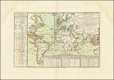
The Planisphere Representant Tout L'Etendue du Monde. Dans L'Ordre Qu'on a Suivi Dans Ce Livre, published by Louis Renard in Amsterdam around 1715, showcases a distinctive north polar azimuthal projection, carried on the shoulders of the mythological figure Atlas. Within this projection are remarkable geographical representations, including a large Northwest Passage in North America and a highly elongated depiction of the Island of California. Furthermore, the extension of Australia across sixty degrees, placing its eastern shore north of New Zealand, adds to the intrigue of the map.
This planisphere emerges from an era of exploration and cartographic innovation, reflecting both the known geography of the time and the mysteries yet to be unraveled. The early 18th century saw European powers extending their reach across the globe, and the maps of the time were vital tools for navigation, exploration, and colonial expansion. The emphasis on the Northwest Passage, a fabled route through the Arctic that would connect the Atlantic and Pacific Oceans, illustrates the era's relentless pursuit of trade and discovery.
The inclusion of the "Terres Inconnues" and the elongated depiction of the Island of California are noteworthy. These features represent the limitations and inaccuracies of geographical knowledge of the time, where the boundaries between myth and reality were not always clearly delineated. The unusual rendering of Australia further underscores the challenges faced by cartographers in accurately portraying lands that were still largely unexplored by Europeans.
Supported by the crouching figure of Atlas, a symbol of strength and endurance, the planisphere is not only a historical artifact but also a piece of art reflecting the human quest for understanding and mastery of the world. The combination of geographical detail, mythological imagery, and unique projection makes this map an exemplar of the cartographic creativity and ambition of its time. It provides a snapshot of a world on the brink of new discoveries, where the known and unknown coalesce in a captivating visual representation.

![[SAS -- Polar Airline Route]](https://storage.googleapis.com/raremaps/img/small/71578.jpg)
![Gerardus Mercator . . . [and] . . . Iudocus Hondius . . .](https://storage.googleapis.com/raremaps/img/small/78439.jpg)