|
||

|

|
|

|
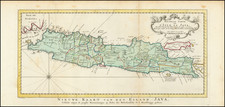
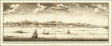
Plan of the Road and City of Batavia on the North Coast of Java Island, published on April 20, 1778 by Sayer & Bennett, is a detailed and historically significant cartographic representation of Batavia, now known as Jakarta, and its surrounding maritime landscape. Presented as a sea chart of the coastal regions opposite Jakarta referred to here as the Entrance of the Batavia Road, the map is based upon a Dutch original by noted chartmaker Gerard Van Keulen, and offer a comprehensive the environs Jakarta during the late 18th century,with detailed soundins off the the coast of the City of Batavia (based on feet) a detailed entrance to the harbor via a narrow channel through a shallow reef and the "Morass [of] Marshy Ground" opposite the harbor.
The map features an inset in the lower left, titled The City of Batavia and its District, providing a closer look at the urban layout of Batavia. The main map, meanwhile, extends beyond the city to include a variety of small islands and reefs. Notably, it provides historical notes on the groundings of British and Dutch vessels including the Poppies in 1703 an the Rygersdall in 1705, offering a glimpse into the maritime history of the region.
One of the key features of the map is the depiction of the fort at Onrust Island, a significant site during the Dutch colonial period. The map also includes other constituent islands of the Thousand Islands, a chain of islands to the north of Jakarta's coast. These features underscore the strategic importance of Batavia and its surrounding waters during the era of European colonial expansion in Southeast Asia.
At the time the map was published, Batavia served as the administrative and commercial center of the Dutch colonial empire in the East Indies. This map, therefore, serves as a valuable historical document, capturing the geography and urban layout of Batavia at a time when it was a hub of trade and colonial administration.
At later edition of the map was issued by Laurie & Whittle in 1794 in with improvements by Captain Henry Smedley, who seems to have undertaken surveys of the region aboard the Raymond, and whose observations were used to correct a number of Sayer & Bennett charts of the region.
Robert Sayer (ca. 1724-1794) was a prominent London map publisher. Robert’s father was a lawyer, but his older brother married Mary Overton, the widow of prominent mapmaker Philip Overton and the proprietor of his shop after his death. Mary continued the business for roughly a year after her marriage and then, in early 1748, it passed to Robert. Robert became a freeman of the Stationers’ Company later that year; his first advertisement as an independent publisher was released in December.
Sayer benefited from Overton’s considerable stock, which included the plates of John Senex. In the 1750s, Sayer specialized in design books and topographical prints, as well as comic mezzotints. In 1753, he, along with John Roque, published a new edition of Thomas Read’s Small British Atlas, the first of several county atlases that Sayer would publish.
Sayer’s business continued to grow. In 1760 he moved further down Fleet Street to larger premises at 53 Fleet Street. In 1766, he acquired Thomas Jefferys’ stock when the latter went bankrupt. In 1774, he entered into a partnership with John Bennett, his former apprentice. The pair specialized in American atlases, based on the work of Jefferys. They also began publishing navigational charts in the 1780s and quickly became the largest supplier of British charts in the trade.
Bennett’s mental health declined, and the partnership ended in 1784. As Sayer aged, he relied on his employees Robert Laurie and James Whittle, who eventually succeeded him. He spent more and more time at his house in Richmond. In 1794, he died in Bath.
John Bennett (fl. 1760-d. 1787) was a London printer best known for his role in the successful partnership of Sayer & Bennett. In 1760, Bennett became a servant of Robert Sayer (ca. 1724-1794), the prominent print and map seller, and was apprenticed to him in 1765. In 1774, Bennett became a free journeyman and entered into a partnership with Sayer. They issued joint advertisements and publications. In 1777, Bennett owned 1/3 share in the business. The partnership was likely to continue fruitfully, but in 1781 Bennett began to show signs of mental illness. In 1783, he was admitted to an asylum for nine months and, in 1784, Sayer filed papers to dissolve their business partnership. Bennett died in 1787.