


|
||

|

|
|

|
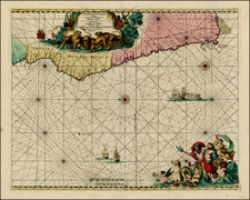
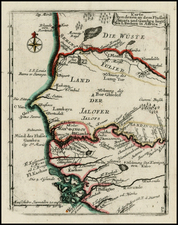
Detailed regional map, extending from Bramas to Angola and inland to Sierras de Cristobal and Salnitre.
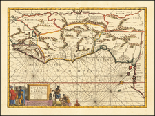
Striking map of western part of Central Africa, specifically the Congo region. The map illustrates a complex network of rivers, coastlines, and internal regions, all rendered with delicate precision, focusing on the region between the Congo River and Luongo River.
The Congo region, depicted in this map, experienced significant transformations during the first half of the 17th century. The Kingdom of Kongo, a prominent state in the region, had established ties with the Portuguese since the late 15th century. The 17th century saw a increase in trade, especially with European powers taking keen interest in the African coast. European powers were motivated by converting locals to Christianity and controlling the burgeoning trade routes. As the century progressed, other European nations, including the Dutch, British, and French, began to establish their presence.
The Kongo Kingdom, initially a potent entity in its own right, became heavily involved in European trade, supplying a significant number of slaves to the Portuguese.
Jodocus Hondius the Elder (1563-1612), or Joost de Hondt, was one of the most prominent geographers and engravers of his time. His work did much to establish Amsterdam as the center of cartographic publishing in the seventeenth century. Born in Wakken but raised in Ghent, the young Jodocus worked as an engraver, instrument maker, and globe maker.
Hondius moved to London in 1584, fleeing religious persecution in Flanders. There, he worked for Richard Hakluyt and Edward Wright, among others. Hondius also engraved the globe gores for Emery Molyneux’s pair of globes in 1592; Wright plotted the coastlines. His engraving and nautical painting skills introduced him to an elite group of geographic knowledge seekers and producers, including the navigators Drake, Thomas Cavendish, and Walter Raleigh, as well as engravers like Theodor De Bry and Augustine Ryther. This network gave Hondius access to manuscript charts and descriptions which he then translated into engraved maps.
In 1593 Hondius returned to Amsterdam, where he lived for the rest of his life. Hondius worked in partnership with Cornelis Claesz, a publisher, and maintained his ties to contacts in Europe and England. For example, from 1605 to 1610, Hondius engraved the plates for John Speed’s Theatre of the Empire of Great Britaine.
One of Hondius’ most successful commercial ventures was the reprinting of Mercator’s atlas. When he acquired the Mercator plates, he added 36 maps, many engraved by him, and released the atlas under Mercator’s name, helping to solidify Mercator’s reputation posthumously. Hondius died in 1612, at only 48 years of age, after which time his son of the same name and another son, Henricus, took over the business, including the reissuing of the Mercator atlas. After 1633, Hondius the Elder’s son-in-law, Johannes Janssonius, was also listed as a co-publisher for the atlas.