|
||

|

|
|

|
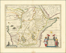
Guinea, a small format map created by Jodocus Hondius and published in London by Michael Sparke and Samuel Cartwright in 1635, delineates the coastal region of Africa stretching from Senegal to Nigeria. Marking key locations such as Elmina and the Portuguese slave fort, the map also features a large inset of the island of Sao Tomé, another vital Portuguese slave base. With decorations including a large strapwork cartouche for the title and a sea monster, this map was featured in the work Historia mundi, or, Mercator's Atlas. Containing his Cosmographical Description of the Fabricke and Figure of the World.
Set within the context of early 17th-century maritime exploration and the burgeoning trans-Atlantic slave trade, this map reflects the geographical knowledge and commercial interests of European powers, particularly the Portuguese, in West Africa. The marked locations such as Elmina and Sao Tomé serve as poignant reminders of the grim trade in human lives that marked this period, with these sites acting as significant hubs in the transportation of enslaved Africans.
The publication history of the map is significant in illustrating the evolution of cartographic knowledge and accessibility. Initially part of the Atlas Minor, the pocket version of the Mercator atlas first published in 1607, the map later became part of English works, including Samuel Purchas's Hakluytus Posthumus, or Purchas his Pilgrimes in 1625, and eventually the Historia Mundi, the first English edition of the 'Atlas Minor', translated by Wye Saltonstall.
In summary, Guinea stands as an important cartographic record of West Africa during a critical period in history, revealing not only geographical knowledge but also the dark connections between exploration and the slave trade. Its varied publication history and distinctive visual features contribute to its enduring relevance as a reflection of early 17th-century geopolitics, commerce, and culture.
Jodocus Hondius the Elder (1563-1612), or Joost de Hondt, was one of the most prominent geographers and engravers of his time. His work did much to establish Amsterdam as the center of cartographic publishing in the seventeenth century. Born in Wakken but raised in Ghent, the young Jodocus worked as an engraver, instrument maker, and globe maker.
Hondius moved to London in 1584, fleeing religious persecution in Flanders. There, he worked for Richard Hakluyt and Edward Wright, among others. Hondius also engraved the globe gores for Emery Molyneux’s pair of globes in 1592; Wright plotted the coastlines. His engraving and nautical painting skills introduced him to an elite group of geographic knowledge seekers and producers, including the navigators Drake, Thomas Cavendish, and Walter Raleigh, as well as engravers like Theodor De Bry and Augustine Ryther. This network gave Hondius access to manuscript charts and descriptions which he then translated into engraved maps.
In 1593 Hondius returned to Amsterdam, where he lived for the rest of his life. Hondius worked in partnership with Cornelis Claesz, a publisher, and maintained his ties to contacts in Europe and England. For example, from 1605 to 1610, Hondius engraved the plates for John Speed’s Theatre of the Empire of Great Britaine.
One of Hondius’ most successful commercial ventures was the reprinting of Mercator’s atlas. When he acquired the Mercator plates, he added 36 maps, many engraved by him, and released the atlas under Mercator’s name, helping to solidify Mercator’s reputation posthumously. Hondius died in 1612, at only 48 years of age, after which time his son of the same name and another son, Henricus, took over the business, including the reissuing of the Mercator atlas. After 1633, Hondius the Elder’s son-in-law, Johannes Janssonius, was also listed as a co-publisher for the atlas.
![[West Coast Africa: Sierra Leone, Liberia and Guinea]](https://storage.googleapis.com/raremaps/img/small/40123.jpg)
![[West Africa] Zaara](https://storage.googleapis.com/raremaps/img/small/92253.jpg)