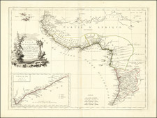
|
||

|

|
|

|
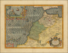
The 17th-century English map titled "Regna Congo et Angola" provides a detailed view of the regions of Congo and Angola in West Africa. Based on the design published by Willem Blaeu in Amsterdam, it meticulously charts the territories, placing significant emphasis on the major river systems and key trading posts of the era.
Central to the map is the depiction of the Zaire (Congo) River and the Coanza River, which are shown to have a common origin at the Aquilunda Lake, The Congo River, one of Africa's most extensive and vital waterways, was instrumental in trade and transportation. Its navigable stretches and tributaries facilitated access deep into the continent, making it a prized route for explorers and traders alike. The Coanza River, significant for Angola, played a role in the establishment and sustenance of several settlements along its banks.
Several trading forts and cities dot the map, marking points of interaction, trade, and conflict. Notable among them would be São Salvador, once the capital of the Kingdom of Kongo, and Luanda, the present-day capital of Angola, which was a major Portuguese trading fort at the time. Luanda, in particular, grew in prominence as a significant slave trading port. The Portuguese had established a fort here, Fortaleza de São Miguel, which functioned as a base for their expanding interests in the region.
By the 17th century, the Kingdom of Kongo had witnessed considerable external influence, primarily from the Portuguese who had established themselves firmly in neighboring Angola. The Portuguese colony in Angola was centered around Luanda, from where they exerted control and facilitated the burgeoning transatlantic slave trade. As the demand for slaves in the New World plantations grew, both Congo and Angola became central to these operations.
The relationship between European powers, especially the Portuguese, and the local kingdoms was multifaceted. While there was conflict, there was also cooperation. Local leaders and chieftains, driven by power dynamics and the lure of European goods, sometimes collaborated with Europeans, capturing and trading slaves in exchange for weapons, textiles, and other goods.
John Ogilby (1600-1676) was an English geographer and publisher, one of the most prominent of the seventeenth century. Little is known of his early life but by 1619 he was apprenticed to John Draper, a dancing-master in London. He worked as a dancing-master, courtier, and theater owner form 1620-1641. From 1649 he worked as a poet, translator, and publisher of classical texts. It is only in the last decade of his life that he entered into geography.
In 1649, Ogilby published his first translation, of Virgil, and continued to put out translations in the 1650s and 1660s. In March 1661 he was reconfirmed as master of revels in Ireland and appointed master of the king’s imprimeries, or king’s printer. From 1662 to 1665 he was in Ireland, where he most likely met Robert Boyle. He returned to London only to lose much of his printing stock in the Great Fire of 1666. Post-fire, he became assistant surveyor to the city, where he met Robert Hooke and Christopher Wren.
In 1669, Ogilby published Embassy to China. At the same time, he planned to release atlases that would cover the entire world. These atlases would be funded via subscriptions, advertisements, and lotteries—all common practice at the time, especially for expensive multi-volume works. He released Africa and Atlas Japannensis in 1670, America in 1671 and Atlas Chinensis in 1671, and Asia in 1673. Ogilby compiled the works based on materials produced by others and they reflect a growing interest in the wider world within England.
In 1671, while producing the atlases, Ogilby secured another royal title, that of his Majesty’s cosmographer. He used this title when publishing Britannia in 1675, his best-known work. The Britannia is best described as a road atlas; it shows 2519 miles of road in 100 strip maps. This technique would be widely adopted in the subsequent century. His method of measuring with a waywiser, a large wheel, also helped to standardize the distance of the English mile at 1760 yards. The Britannia was a major achievement in early English cartography and was republished in 1698, 1719, and 1720.
![[Northern Nigeria Protectorate]](https://storage.googleapis.com/raremaps/img/small/70705.jpg)
![[West Africa] Zaara](https://storage.googleapis.com/raremaps/img/small/92253.jpg)