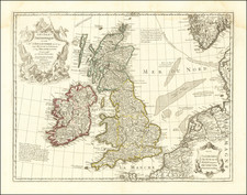
![[ Roman British Isles] Britannicae Insulae, in quibus Albium sive Britannia Maior Iuernia sive Britannia Minor, tum et Orcades, Ebudes, Cassiterides By Pierre Mortier](https://storage.googleapis.com/raremaps/img/small/89461.jpg)


|
||

|

|
|

|
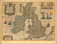
The Roman Roads of Britain
Beautiful map of the British Isles during the Classical Period, published in the late 17th century in Amsterdam by Pierre Mortier.
In the late 17th century, the city of Amsterdam was known for its production of intricately designed and historically significant maps. This particular map offered a window into the past, representing the British Isles as they appeared during the Classical Period under Roman control. With a remarkable attention to detail, Mortier's map portrays not only the physical geography but the historical landscape of England, Wales, Scotland, and Ireland.
The map captures the British Isles at a time when they were central to Roman expansion and administration. England, known in Roman times as Britannia, was a crucial part of the Roman Empire, especially after Emperor Claudius's invasion in 43 AD.
Scotland, though less impacted by the Romans, still tells a fascinating story through the map. Hadrian's Wall, highlighted with precision on the map, marked the northern boundary of the Roman Empire in Britannia. Stretching 73 miles across the island, the wall was not merely a defensive structure but a symbol of Roman authority and engineering prowess. North of the wall lay the unconquered lands of the Picts, depicted with mystique on Mortier's map. Also shown is the Vallum Severi, or Severus's Wall, a defensive structure often associated with the Roman Emperor Septimius Severus. During his campaign in Britannia in the early 3rd century AD, Severus sought to subjugate the tribes north of Hadrian's Wall and further solidify the Roman presence in the region.
What can be said with more certainty is that the wall represents a period of renewed Roman interest in the northern reaches of Britannia, reflecting Severus's ambitious and ultimately ill-fated efforts to bring the entire island under Roman control. Its depiction on the map by Pierre Mortier adds to the historical richness of the representation, connecting the late 17th-century viewer to a distant era of imperial ambition and frontier warfare.
Wales, in the western part of the island, was renowned for its rich mineral resources. Through an expansive network of roads, the Romans linked Wales's mines with other parts of Britannia. The map traces these roads, allowing one to imagine the journey of a Roman merchant transporting precious metals to far-reaching corners of the Empire.
In Ireland, referred to as Hibernia by the Romans, the history was somewhat different. Although never fully conquered by the Romans, the map still reflects a Roman perspective of this island, marking important trading ports and the routes connecting them. Here, too, the network of Roman roads plays a significant role in conveying a historical moment in time.
The major Roman Roads illustrated on Mortier's map are a marvel of ancient engineering. They were the veins and arteries of Roman Britain, connecting military bases, administrative centers, and vital resources. For instance, the road known as Watling Street provided a strategic route from Dover in the southeast through London to the frontier at Hadrian's Wall. Another critical road, the Fosse Way, linked Exeter in the southwest to Lincoln in the northeast, representing a significant line of communication across Britannia. Mortier's depiction of these roads even transcending the English Channel symbolizes the extensive reach of the Roman Empire, binding the British Isles to the continental heart of Rome. They were more than mere pathways; they were the manifestation of Rome's ambition, order, and control.
Johannes Covens (1697-1774) was a Dutch geographic publisher based in Amsterdam. He is best known for his collaboration with fellow publisher Cornelis Mortier (1699-1783). Pierre Mortier the Elder (1661-1711) had obtained a privilege in 1690 to distribute the works of French geographers in the Netherlands. After his widow continued the business for several years, Cornelis took over in 1719.
In 1721, Mortier forged a partnership with Covens, who had recently married Cornelis’ sister. They published under the joint name of Covens & Mortier. In 1774, upon the death of his father, Johannes Covens II (1722-1794) took over his father’s share. In 1778, the company changed its name to J. Covens & Zoon, or J. Covens & son.
Covens II’s son, Cornelis (1764-1825), later inherited the business and brought Petrus Mortier IV back into the fold. Petrus was the great-grandson of Petrus Mortier I. From 1794, the business was called Mortier, Covens & Zoon, or Mortier, Covens, & Son.
The business specialized in publishing French geographers including Deslisle, Jaillot, and Sanson. They also published atlases, for example a 1725 reissue of Frederik de Wit’s Atlas Major and an atlas, with additions, from the works of Guillaume Delisle. There were also Covens & Mortier pocket atlases and town atlases. The company profited from acquiring plates from other geographers as well. For example, the purchased Pieter van der Aa’s plates in 1730. Finally, they also compiled a few maps in house. At their height, they had the largest collection of geographic prints ever assembled in Amsterdam.
Pierre, or Pieter, Mortier (1661-1711) was a Dutch engraver, son of a French refugee. He was born in Leiden. In 1690 he was granted a privilege to publish French maps in Dutch lands. In 1693 he released the first and accompanying volume of the Neptune Francois. The third followed in 1700. His son, Cornelis (1699-1783), would partner with Johannes Covens I, creating one of the most important map publishing companies of the eighteenth century.