|
||

|

|
|

|
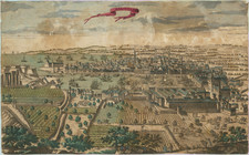
Interesting woodcut plan illustrating the Siege of Metz (1552-1553), which first appeared in Munster's Cosmographia in 1554.
The Siege of Metz lasted from October 1552 to January 1-5, 1553, during the so-called Italian War of 1551–59. This conflict was embedded in a larger struggle involving religious and political ambitions throughout Europe.
The conflict's backdrop was set by the end of the Augsburg Interim, a period of religious tension and division. The Protestant princes of the Schmalkaldic League, seeking support against the Holy Roman Emperor Charles V, reached out to Henry II of France. The outcome of this collaboration was the Treaty of Chambord, wherein the free cities of Toul, Verdun, and Metz, known as the 'Three Bishoprics', were ceded to the Kingdom of France.
Subsequent to this treaty, Charles V, in an attempt to reclaim these territories, laid siege to Metz, which was fortified and manned by a French garrison under the command of Francis, Duke of Guise. The siege saw significant bombardment, with cannonades causing extensive damage to the medieval fortifications of Metz. Yet, despite the superior firepower and the intensity of the siege, the Imperial forces could not breach the city's defenses.
The situation for Charles V and his army grew dire as diseases, namely typhus, dysentery, and scurvy, ravaged the ranks. These health crises, combined with the resilient defense of Metz, forced Charles to make a strategic withdrawal, leaving behind those too sick or injured to travel.
Post-siege, Metz operated as a French protectorate, known as "République messine", until 1648. It was only with the Treaty of Westphalia that Metz's annexation to France was formalized.
Münster's Cosmographia was the first German-language description of the world, and one of the defining books of the Renaissance. It contained 471 woodcuts and 26 maps over six volumes. First published in 1544, the Cosmographia was hugely popular in addition to being influential for contemporary cartographers like Mercator and Ortelius. It was published in at least 35 editions by 1628; these editions included examples in Latin, French, Italian, English, and Czech. After Münster's death, Henri Petri, and later his son, Sebastien Petri, took charge of printing editions.
Münster drew from his own travels in the work in addition to using other ancient and more modern sources. These sources included Herodotus, Strabo, and Titius Livius, as well as Marcantonio Sabellico, Beatus Rhenanus, and Aegidius Tschudi. Münster additionally collected reports from recent travelers, which he integrated into his descriptions. These descriptions generally included detailed overviews of the customs, dress, and organization of peoples around the world, earning him a prominent place in the histories of geography and anthropology.
![[Blois] Bloys](https://storage.googleapis.com/raremaps/img/small/77625.jpg)
![[ Saint-Denis ] Pourtraict de la Ville de Sainct Denis en France](https://storage.googleapis.com/raremaps/img/small/74991.jpg)
![[Marseille] Marsilia](https://storage.googleapis.com/raremaps/img/small/61341sb.jpg)
![[Marseille] Le Vray Portraict de la Ville de Marseille.](https://storage.googleapis.com/raremaps/img/small/75483.jpg)