|
||

|

|
|

|
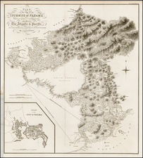
Rare first state this Spanish sea chart of the coastline of Colombia and Panama.
Quarta Hoja que Comprehende las Costas de la Provincia de Cartagena, Golfo Del Darien y Provincio de Porto Velo con el Golfo de Panama y Archipelago de las Perlas, printed in Madrid in 1817, represents the maritime geography of Colombia and Panama. As a sea chart from the first state of its edition, it captures the maritime survey work of Brigadier Joaquin Franciso Fidalgo from the late 18th century, a time when Colombia and Venezuela were on the cusp of independence.
The 18th century saw the Spanish territories in the Americas approaching a significant shift in political dynamics. Within this context, the necessity for accurate maritime navigation led to detailed charting. The hydrographical expeditions of Fidalgo and Churruca inform the Quarta Hoja. Their work primarily focused on the North American coastlines, aiming to improve Spanish maritime commerce in regions such as the Gulf of Mexico, Florida, and the Antilles.
Joaquin Francisco Fidalgo's contributions to Spanish naval exploration were notable. Having been appointed commander in 1791, he led a division of brigs in collaboration with Churruca. Their explorations extended to territories between Panama and Guajira, Venezuela. Fidalgo's involvement in naval matters continued with the establishment of a nautical school in Cartagena de Indias. By 1810, Fidalgo took on the role of commander of the Hydrographic Office in Spain.
The chart's utility is underlined by its detailed depiction of the maritime terrain. A legend indicates various seabed types from "A. Arena" (sand) to "P. Piedra" (stone). Regions such as the "Archipelago de la Perlas" and the provinces of "Port Velo," "Darien del Norte," "Panama," and "Cartagena" are also precisely marked, reflecting the geography of the period.
The Dirección de Hidrografía, or the Directorate of Hydrographic Works, was established in 1797. Its roots were in the Casa de Contratación, founded in 1503 in Sevilla, which housed all the charts of the Spanish Empire and oversaw the creation and maintenance of the padrón real, the official master chart. The Casa, now in Cadiz, was shuttered in 1790, but Spain still needed a hydrographic body. In response, the Dirección was created in 1797. One of its first projects was the publication of charts from the Malaspina Expedition (1789-1794). The Dirección oversaw not only publication, but also surveying. The Dirección was abolished in the early twentieth century, when their work was distributed to other organizations.
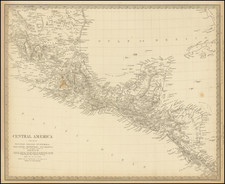
![[Central America]](https://storage.googleapis.com/raremaps/img/small/77960.jpg)
![[Fruit Crate Label Advertising Map] Panama Brand (North America & Panama Canal)](https://storage.googleapis.com/raremaps/img/small/48860.jpg)