|
||

|

|
|

|
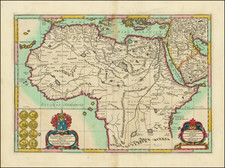
Interesting map of the classical region of "Barbaria" by Joannes Blaeu. Published in Amsterdam, this two-part map provides a detailed view of northern Africa during an era of immense change, exploration, and colonial ambition.
The upper segment of the map showcases the entirety of the northern African coastline. It stretches from the west coast of Africa south of Morocco in the west to the powerful Nile River in the east. Notably, regions like Zanhaga and Gualata Regnum are marked. The name Zanhaga probably refers to the Zenaga Berbers, who were native to the region and played pivotal roles in the region's early Islamic history. The Gualata Regnum, on the other hand, is a reference to the ancient African Kingdom of Gualata, a region that was part of the broader Sahelian belt of Africa, known for its trans-Saharan trade and flourishing civilizations.
The bottom half of "Barbaria" zooms in on the regions centered on Algeria and Tunisia. This depiction offers a focused view of the central Maghreb region, an area rich in history, with legacies from the Phoenicians, Romans, Berbers, and Arabs.
Barbaria in the 16th and 17th Centuries
The term "Barbaria" finds its origin in the Greek word "Barbaros," meaning foreign or barbarian, which the Greeks used to describe non-Greek speaking people. In the context of North Africa, "Barbaria" referred to the region inhabited predominantly by the Berbers. The name became synonymous with the North African coast and was widely used in Europe.
During the 16th and 17th centuries, Barbaria or North Africa became a battleground for the contesting European powers, particularly Spain and the Ottoman Empire. The Ottomans, under the leadership of Barbarossa and later his successors, expanded their rule in the Maghreb, establishing their dominance in modern-day Algeria, Tunisia, and parts of Libya.
Apart from the geopolitical skirmishes, the coast of Barbaria was infamous for piracy. The Barbary pirates, as they were known, posed threats to European shipping in the Mediterranean. They were not just pirates but corsairs, often state-sponsored privateers, operating with the backing of local rulers or the Ottoman Empire itself. European captives taken by these pirates often ended up as slaves or were held for ransom.
Simultaneously, the Sahara served as a conduit for extensive trade networks. Gold, salt, and slaves were among the major commodities that passed through trans-Saharan routes, linking sub-Saharan Africa with the North African coast.
Joan, or Johannes, Blaeu (1596-1673) was the son of Willem Janszoon Blaeu. He inherited his father’s meticulous and striking mapmaking style and continued the Blaeu workshop until it burned in 1672. Initially, Joan trained as a lawyer, but he decided to join his father’s business rather than practice.
After his father’s death in 1638, Joan and his brother, Cornelis, took over their father’s shop and Joan took on his work as hydrographer to the Dutch East India Company. Joan brought out many important works, including Nova et Accuratissima Terrarum Orbis Tabula, a world map to commemorate the Peace of Westphalia which brought news of Abel Tasman’s voyages in the Pacific to the attention of Europe. This map was used as a template for the world map set in the floor of the Amsterdam Town Hall, the Groote Burger-Zaal, in 1655.
Joan also modified and greatly expanded his father’s Atlas novus, first published in 1635. All the while, Joan was honing his own atlas. He published the Atlas maior between 1662 and 1672. It is one of the most sought-after atlases by collectors and institutions today due to the attention to the detail, quality, and beauty of the maps. He is also known for his town plans and wall maps of the continents. Joan’s productivity slammed to a halt in 1672, when a fire completely destroyed his workshop and stock. Joan died a year later and is buried in the Westerkerk in Amsterdam.
![[ Ethiopia, Sudan & Eritrea ] Nubia and Abysssinia](https://storage.googleapis.com/raremaps/img/small/101736.jpg)
![(Tangiers, Tzaffin, Ceuta, Arzila, and Sala) Tingis Lusitanis Tangiara. . . [on sheet with] Tzaffin [and] Salaa [and] Arzilla
[and] Septa](https://storage.googleapis.com/raremaps/img/small/54983mp2.jpg)