|
||

|

|
|

|
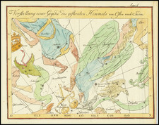
Rare Celestial Engraving of the Comet of 1618 by Caspar Hersbach
Fine example of this extremely rare Caspar Hersbach - Frans Hogenberg engraving of the transit of the December 1618 comet.
In an era where the heavens were a source of both mystery and fascination, celestial maps, or sky charts, were not merely tools of navigation or scholarly study, but were also pieces of art, rich with intricate detail and symbolism. One such celestial chart that captures the imagination is the copper plate engraving of the comet of 1618, meticulously crafted by Caspar Hersbach.
In the upper right quadrant is a meticlulous depiction of the comet of 1618, tracing its path across the night sky. The text on the map, translated from its original German, provides a narrative account of the comet's appearance and path, revealing that it first became visible on the 6th of December near the constellation Bootes, hovering over regions such as Africa and East India. By the 22nd of that month, it graced the skies over Cologne and subsequently disappeared beyond the horizons of Sweden, Norwegian America, and other Norse territories. Such specific details allow viewers to appreciate not just the marvel of the comet, but the precision and dedication with which observers of the era charted its movement.
This map isn't simply a record of an astral event; it paints a vivid picture of the northern celestial hemisphere. Hesrbach has carefully marked the positions of the comet between December 6 and 28, providing an illustrative guide to its movement across the night sky. The constellations are rendered in a classic style. These artistic renditions of the constellations offer both aesthetic appeal and educational value, providing context for the comet's path.
Below the main depiction, there's a separate representation of the comet itself, accompanied by an informative text, which tells of its impressive size: a height of 30,129 miles and a length of 8,032 miles. The magnitude of such dimensions, especially for a comet, captures the grandeur of celestial bodies and the awe they can inspire.
The planisphere, or the representation of the celestial sphere, is at the core of the engraving, beautifully projected with the earth's pole at its center, with images of four allegorical winds blowing from the corners, a curious and perhaps strictly decorative decision, although, in the time of the poet Homer the four winds were the cardinal directions with the north wind, Boreas blowing up rough waves; Notus, the south wind, causing sudden storms; Zephryus, the west and Eurus, the east winds. The prophet Jeremiah also speaks of "the four winds from the four corners of heaven" (Jeremiah 49: 36).
The chart, demarcated with the equator as its maximum circle, is richly colored, making it vibrant and alive. Around this central depiction, Hersbach has placed four allegorical figures, enriching the narrative and adding layers of meaning to the artwork.
The translation of the full text title is:
"Actual directory of the comet that appeared in the year 1618, which shows its course or movement through the signs of the 8th heaven, is presented here before our eyes. This comet first showed light on the 6th of December near the shin of BOOTIS over Africa and East India, subsequently on the 22nd of the same month, it moved over the city of Cologne and finally disappeared over Sweden, Norwegian America, and similar Norwegian lands as can be further read in my small book. Designed by M. Casparus Hersbach of Cologne"
Caspar Hersbach meticulously documented the 1618 comet's path, as did Johannes Kepler, the German astronomer best known for his laws of planetary motion. Another towering figure of the Renaissance, Galileo Galilei, delved into the nature of the December comet in his work "Il Saggiatore".
Rarity
OCLC locates 1 copy, at the Heinrich Heine Universitat Dusseldorf. We also note a colored example in the collection of the British Museum and an uncolored example bound into a composite atlas at the Rijksmuseum.
The example at the University of Dusseldorf and at the Rijksmuseum credit Frans Hogenberg the primary maker. The Database of Scientific Illustrators 1450-1950 also credits Hogenberg as the maker.
We note that the map is listed in the Catalogue of the Crawford Library of the Royal Observatory Edingburgh, 1890, at page 177.
Frans Hogenberg (ca. 1540-ca. 1590) was a Flemish and German engraver and mapmaker who also painted. He was born in Mechelen, south of Antwerp, the son of wood engraver and etcher Nicolas Hogenberg. Together with his father, brother (Remigius), uncle, and cousins, Frans was one member of a prominent artistic family in the Netherlands.
During the 1550s, Frans worked in Antwerp with the famous mapmaker Abraham Ortelius. There, he engraved the maps for Ortelius’ groundbreaking first atlas, published in Antwerp in 1570, along with Johannes van Deotecum and Ambrosius and Ferdinand Arsenius. It is suspected he engraved the title page as well. Later, Ortelius supported Hogenberg with information for a different project, the Civitates orbis terrarium (edited by Georg Braun, engraved by Hogenberg, published in six volumes, Cologne, 1572-1617). Hogenberg engraved the majority of the work’s 546 prospects and views.
It is possible that Frans spent some time in England while fleeing from religious persecution, but he was living and working in Cologne by 1580. That is the city where he died around 1590. In addition to his maps, he is known for his historical allegories and portraits. His brother, Remigius, also went on to some fame as an engraver, and he died around the same time as his brother.
![Auriga, The Charioteer [with Herschel's Telescope]](https://storage.googleapis.com/raremaps/img/small/67687.jpg)
![[ Great Comet of 1264 ]](https://storage.googleapis.com/raremaps/img/small/98753.jpg)
![(Sundial) Horologium Horizontale [Fig. 10 Cap II]](https://storage.googleapis.com/raremaps/img/small/78870.jpg)