|
||

|

|
|

|
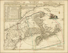
Karte Von Der Insel Montreal und den Gegenden Umher, published by Gabriel Nikolaus Raspe in Nuremberg in 1764, stands as an important representation of the area surrounding Montreal during the French & Indian War. The cartographic rendering illustrates both the vast landscape of the island and a detailed plan of the City of Montreal itself, derived from the earlier groundwork by Bellin circa 1744. This edition, however, distinguishes itself with the comprehensive illustration of the city's layout, offering a distinctive view into one of North America's burgeoning urban centers of the mid-18th century.
The mid-1700s was a period of immense geopolitical tension in North America, with the French & Indian War serving as the North American front of the Seven Years' War between Great Britain and France. Montreal, being a significant French colonial settlement, played a crucial role in this conflict. This map, with its detailed representation, captures the strategic importance of Montreal and its surroundings, illustrating both its natural geography and urban layout, critical for military maneuvers and planning.
Raspe's adaptation of Bellin's original plan introduces a fresh perspective on the City of Montreal. While Bellin's work was already esteemed for its precision, Raspe's rendition further underscores the urban growth and development of the city. Such detailed urban portrayals were instrumental in understanding the socio-cultural and architectural evolution of cities in the pre-industrial era. The introduction of a detailed city plan in Raspe's edition hints at the increasing significance of Montreal as a colonial hub, both in terms of its trade and its position in the wider geopolitical landscape.
The rarity of Karte Von Der Insel Montreal und den Gegenden Umher further enhances its value. Its scant appearances on the market over the past decades, as evidenced by the limited listings in the AMPR, underscores its unique position amongst 18th-century cartographic representations of North American territories. The map not only offers an invaluable view into Montreal's landscape during a pivotal era but also exemplifies the artistry and detail that were hallmarks of European cartography during the 18th century.
![[ Newfoundland ] Isola Di Terra Nuova Scoperta da Gio: Cabota Veneto con suo Figliuso Sebastiano l'an 1596 24 Giugno a hore 12 . . .](https://storage.googleapis.com/raremaps/img/small/98645.jpg)
![[ Native Mexican Warrior ] Ein Mexicaner](https://storage.googleapis.com/raremaps/img/small/94089.jpg)