


|
||

|

|
|

|
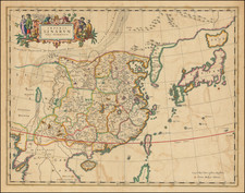
Province de Chen-Si by Jean Baptiste Bourguignon d'Anville, published in Paris in 1735, stands as a pivotal cartographic rendition of the Shaanxi province. This exceptional map, adorned with a detailed pictorial cartouche engraved by Guélard and the mapwork by Delahaye, offers a vivid tableau of animals, armory, and rococo chinoiserie ornamentation, capturing the essence of the region's cultural and natural milieu, as understood by the French in the first half of the 18th century.
D'Anville's significance in 18th-century cartography cannot be overstated; with a legacy of compiling over 200 maps, he is renowned as the paramount cartographic authority on China during the 18th century. His work brought forward a new level of accuracy in Western maps of China, largely owing to his use of maps prepared by Jesuit missionaries under the commission of Emperor Kangxi. It was Emperor Kangxi's visionary decree between 1708-16, which mandated a comprehensive survey of the country, laying the groundwork for D'Anville's meticulous cartographic depiction.
The historical backdrop during which this map was produced accentuates its relevance. The 18th century witnessed the Qing Dynasty at its zenith, with Emperor Kangxi being a luminary figure steering monumental changes in cartographic explorations. Under his aegis, there was a determined emphasis on empirical accuracy, which paved the way for Jesuit missionaries to undertake extensive surveys, thus bridging the East-West knowledge divide.
This map was included the Description géographique, historique, chronologique, politique et physique de l'Empire de la Chine et de la Tartarie chinoise... by P. du Halde.
Jean-Baptiste Bourguignon d’Anville (1697-1782) was one of the foremost French geographers of the eighteenth century. He carried out rigorous research in order to create his maps, which greatly developed the technical proficiency of mapmaking during his lifetime. His style was also simpler and less ornate than that of many of his predecessors. It was widely adopted by his contemporaries and successors.
The son of a tailor, d’Anville showed cartographic prowess from a young age; his first map, of Ancient Greece, was published when he was only fifteen years old. By twenty-two, he was appointed as one of the King’s géographes ordinaire de roi. He tutored the young Louis XV while in the service to the Crown. However, royal appointment did not pay all the bills, so d’Anville also did some work for the Portuguese Crown from 1724. For example, he helped to fill out Dom João V’s library with geographical works and made maps showing Portugal’s African colonies.
D’Anville disapproved of merely copying features from other maps, preferring instead to return to the texts upon which those maps were based to make his own depictions. This led him to embrace blank spaces for unknown areas and to reject names which were not supported by other sources. He also amassed a large personal map library and created a network of sources that included Jesuits in China and savants in Brazil. D’Anville’s historical approach to cartography resulted in magnificently detailed, yet modern and academic, maps. For example, his 1743 map of Italy improved upon all previous maps and included a memoir laying out his research and innovations. The geographer also specialized in ancient historical geography.
In 1773, d’Anville was named premier géographe de roi. In 1780, he ceded his considerable library to the Ministry of Foreign Affairs to be used for as a reference library for diplomats. D’Anville is best known for several maps, including his map of China, first published in 1735, and then included with Du Halde’s history of that country (the Hague, 1737). His map of Africa (1749) was used well into the nineteenth century.
![[Shannxi Province] Xensi, Imperii Sinarum Provincia Tertia](https://storage.googleapis.com/raremaps/img/small/99964.jpg)
![(Russian Adventurism in China) Карта Средней Азии Составлена К. Веберомъ... 1871. [Map of Central Asia Compiled by K. Weber... 1871.]](https://storage.googleapis.com/raremaps/img/small/58597.jpg)
![[Ladrone Islands / Wanshan Archipelago] Ladronen Chine](https://storage.googleapis.com/raremaps/img/small/90221.jpg)