|
||

|

|
|

|
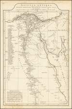
Magnificent Lithograph Bird's-Eye View of the Suez Canal, Published in Toulouse in 1885.
Fine view of the Suez Canal, published in Toulouse and evoking earlier Italian research and perspectives on the canal.
The view credits Giosellino Peverelli for the information, and follows the depiction of a series of views produced in Italy in the 1860s. In the upper left, Cairo and the pyramids are visible. In the upper right is the Nile Delta. At the base of the map is the famous canal, connecting Suez and Port Said.
A notable addition is the meticulously detailed profile of the canal situated below the main view. This profile elegantly delineates the canal's topographical variations, providing an insightful depth and layer to the viewer's understanding. The precise contouring and gradient representation give an almost tactile sense of the canal's physicality, a tribute to the mapmaker's meticulous craftsmanship and attention to detail.
We locate a reference to the work in an 1885 list of French publications from 1884. This is consistent with the date provided by the BNF.
French and Italian Involvement in the Suez Canal
In the 19th century, the Suez Canal emerged as a remarkable testament to engineering and international cooperation, significantly influencing global trade routes. Conceived by Ferdinand de Lesseps, a French diplomat, the canal's construction began in 1859 after he procured a concession from Sa'id Pasha, the Khedive of Egypt and Sudan. The French were instrumental in the canal's realization, with de Lesseps founding the Suez Canal Company to oversee its construction. While Italy didn't play a central role in the canal's construction, Italian visionaries like Cesare Vimercati recognized the canal's potential influence on European trade dynamics. Vimercati, among others, believed that the canal would catalyze a resurgence in Italian maritime prominence, especially given Italy's geographically strategic position. The canal was inaugurated in 1869, providing a direct maritime link between the Mediterranean and the Red Sea, and thus revolutionizing trade by eliminating the lengthy and treacherous voyage around Africa.
Rarity
We locate only a single example of this 1884 edition of the map through OCLC or other means, at the BNF.
![[Grenoble 1968 Winter Olympics] L'Alpe D'Huez France - Isere](https://storage.googleapis.com/raremaps/img/small/84340.jpg)
![[ Paris in the time of the Romans ] Lutece conquise par les Francois sur les Romains ou Second Plan De La Ville De Paris Tire Du Misopogone de l'Empereur Iulien, d'Amian Marceline, de Gergoire de Tours de Boece, de l'abbe suger, des Anciens Titres . . .](https://storage.googleapis.com/raremaps/img/small/103596.jpg)