|
||

|

|
|

|
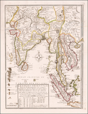
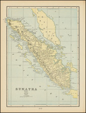
The Coast of India from Pulo Timon to Pulo Cambir, published by Laurie & Whittle in London in 1794, provides a precise sea chart of key regions in Southeast Asia. This chart covers sections of Thailand, Malaysia, the Straits of Malacca, Cambodia, Vietnam, and the northeastern part of Borneo, with particular emphasis on coastal features and details of several major rivers.
During the latter part of the 18th century, the importance of Southeast Asia's maritime routes gained prominence among European powers, with the region becoming increasingly integral for trade and navigation. Nautical charts, such as this one produced by Laurie & Whittle for their Oriental Pilot, catered to the need for accurate maritime information. They offered essential details like soundings and river systems, aiding navigators in traversing these waters.
Both the Gulf of Siam, now the Gulf of Thailand, and the Straits of Malacca held significant roles in regional trade, connecting the Indian and Pacific Oceans. As such, this chart not only served practical navigational purposes but also stands as a document reflecting the evolving trade dynamics and geopolitical considerations of the time.
Robert Laurie (ca. 1755-1836) and James Whittle (1757-1818) formed their Fleet Street, London-based firm upon the 1794 death of their employer Robert Sayer, himself one of the dominant print and mapmakers of the last half of the 18th century.
Laurie & Whittle started managing Sayer's business as early as 1787. They took over all managerial duties when Sayer's health flagged in 1792, and they changed the imprint in 1794 upon his death. Sayer left the two a 21-year lease on the shop (at £100 a year) and on Sayer's Bolt Court premises, as well as an option to acquire stock and equipment at a preferential price of £5,000 payable over three years.
Robert Laurie retired from the firm in 1812, and his role was assumed by his son, Richard Holmes Laurie (1777-1858). The younger Laurie worked with James Whittle until the latter died in 1818. After R. H. Laurie died in 1858, Alexander George Findlay, FRGS (1812-1875) purchased the firm from his daughters. The firm continues today under another name, specializing in yachting charts.
Laurie & Whittle were prolific print and map publishers, and throughout their careers, they produced numerous very important and rare works. They carried on Robert Sayer's atlas business and were responsible for editions of The Complete East-India Pilot and The American Atlas.