|
||

|

|
|

|
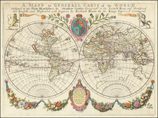
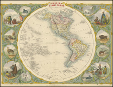
First World Map of Mercator's Projection and An Icon of 16th Century Map Collections
Western half of the extremely rare Christian Knight World map, published by Jodocus Hondius in London in 1596.
The map reflects the geographical knowledge of the world at the end of the 16th century. This was a period when old and new major powers—Spain, England, France, United Provinces—were extensively exploring borderlands, seeking new routes to the Far East. Hondius was well-positioned in both London and Amsterdam to translate this new information into his cartographic work. His map references the three voyages of the English seafarer John Davis (1585-1587) in search of a northwest passage through North America and also notes an overwintering on Nova Zembla (1594-95). Less accurately, he depicts Tierra del Fuego as part of a large, unknown southern continent despite Francis Drake's explorations showing it to be an archipelago.
The title of the map reads: "Typus totius orbis terrarum, in quo & Christiani militis certamen super terram … graphicè designatur," which translates to "The world map in which the struggle of the Christian Knight on Earth is graphically depicted." Centered in the unknown southern land, the Christian Knight stands as a symbol for the concept that life is a struggle and that one must resist the enemies of spiritual well-being. This allegorical theme is aptly described by Paul in his letter to the Ephesians (6, 10-17). Some identify this knight with Henry IV, King of France (1589-1610). The threats are depicted by allegorical figures, and each is substantiated with biblical texts. These figures represent worldly vanity, sin, fleshly weakness, the devil, and death. The ideological intent behind these scenes is suggested by Peter Barber to have been to galvanize Protestant support for Henry IV during his conflict with Catholic powers, most prominently Spain.
The Christian Knight Map is the first map to utilize Mercator's World Projection. This projection, first formulated in 1569, was groundbreaking for its time and had a profound impact on maritime navigation. Notably, Edward Wright in London made significant contributions to the mathematics underlying Mercator's projection. His numerical solutions, published in "Certaine Errors in Navigation" in 1599, were used by Hondius without permission. The relationship between Hondius and Edward Wright became contentious over the unauthorized use of Wright's mathematical solutions. Wright addressed this breach of conduct in the preface of "Certaine Errors," expressing his discontent with Hondius's actions.
In terms of geographical content, the map is one of the early representations of Roanoke, the first English colony in America. It also incorporates the latest maritime data, including the results of circumnavigations by figures like Sir Walter Raleigh, Sir Francis Drake, and Thomas Cavendish.
The map serves as a symbolic representation of the religious and political struggles during the Dutch war of independence against Catholic Spain, which spanned from the 1560s to 1648. Created by Jodocus Hondius, a Dutch Protestant, the map uses allegorical figures to depict the conflict between Catholics and Protestants. The map is rich in symbolism, reflecting the ideological and theological tensions of the period. It also features frightening creatures, likely intensifying the sense of struggle and danger associated with religious and political battles of the time.
At the bottom left, the maker explores the biblical implications of world exploration. The text appears to be a compilation of several biblical verses dealing with the concept of "mundus," or "the world" in Latin. These verses come from different books of the New Testament and emphasize the tension between worldly desires and spiritual pursuits. Here is a transcription followed by a translation of each verse.
-
"Quid enim profuerit cuipiam fi lucratus fuerit mundum totum, anima fua mulétetur Aut qua dabit quifpiam compenfationem anime fue Marc. 8.36":
- Translation: "For what shall it profit a man, if he shall gain the whole world, and lose his own soul? Or what shall a man give in exchange for his soul? (Mark 8:36)"
-
"Nill enim nilimus m mundum, videlicet nec efferre quicquam poffumus. Sed habentes alimenta, quibus teganu, hac nobis fatis erunt. Qui autem volunt difcere, incidunt i tentationem laqueum, cupiditates multas amentes et damnofas, que demergunt homines in exitium et interitun. 1. Timot.6. 7":
- Translation: "For we brought nothing into the world, and we can take nothing out of it. But if we have food and clothing, we will be content with that. Those who want to get rich fall into temptation and a trap and into many foolish and harmful desires that plunge people into ruin and destruction. (1 Timothy 6:7)"
-
"Adulteri nefcitis amicitiam mun h, inimicitia eße adverfus Deum? Quicunqz ergo voluerit amicus eße mundi inimicus Dei confituitur Jacob. 4.4":
- Translation: "You adulterous people, don't you know that friendship with the world means enmity against God? Therefore, anyone who chooses to be a friend of the world becomes an enemy of God. (James 4:4)"
-
"Ne diligite mundum, neque ea que in mundo funt: fi quis diligit mundum non eft charitas patris in eo, Quoniam quicquid eft mundo, cupiditas carnis, libido oculorum, & faftus vite non eft ex patre fed ex mundo. 1.foau 2. 15":
- Translation: "Do not love the world or anything in the world. If anyone loves the world, love for the Father is not in them. For everything in the world—the lust of the flesh, the lust of the eyes, and the pride of life—comes not from the Father but from the world. (1 John 2:15)"
The verses collectively explore the spiritual pitfalls of excessive attachment to worldly gains, advising a focus on spiritual rather than material wealth. They highlight the inherent conflicts between earthly desires and the divine path, underscoring the need for a more ascetic and spiritually-oriented life.
To the right is a discussion about Sin. The text appears to be a compilation of various biblical verses that focus on the concept of "peccatum," or "sin" in Latin. Here is a transcription followed by the translation of each verse:
-
"Qui dat operam peccato, ex diabolo eft: quoniam à principio diabolus peccat Joan 3.8."
- Translation: "He who commits sin is of the devil, for the devil has sinned from the beginning. (1 John 3:8)"
-
"Stipendia peccati mors: Rom. 6. 23"
- Translation: "For the wages of sin is death. (Romans 6:23)"
-
"In fua imprudentia intercipictur peccator, Ecclef. 23. 7."
- Translation: "In his imprudence, the sinner is caught. (Ecclesiasticus/Sirach 23:7)"
-
"Sed Deo fit gratia, qui dat nobis victo riam per Dominum noftrum Jefum Chriftum. 1 Corin 15. 57."
- Translation: "But thanks be to God, who gives us the victory through our Lord Jesus Christ. (1 Corinthians 15:57)"
-
"Aculeus autem mortis, peccatum: potentia vero peccati lex. ibidem"
- Translation: "The sting of death is sin, and the power of sin is the law. (1 Corinthians 15:56, referenced as "ibidem" meaning "in the same place")"
These verses offer a theological meditation on the nature of sin, its origin, its consequences, and ultimately, the redemption that comes through Jesus Christ. They speak to the perilous outcomes of sin, notably spiritual death, but also highlight the grace and victory that can be attained through divine intervention. The compilation serves as a comprehensive doctrinal statement on the topic of sin within Christian theology.
Rarity
The map is known in six institutional examples: (Clements Library (Michigan); British Library; Royal Geograpical Society (London); German National Musuem (Nuremberg); Holkham Hall (Innys Collection); Österreichische Akademie der Wissenschafte (Vienna).
Jodocus Hondius the Elder (1563-1612), or Joost de Hondt, was one of the most prominent geographers and engravers of his time. His work did much to establish Amsterdam as the center of cartographic publishing in the seventeenth century. Born in Wakken but raised in Ghent, the young Jodocus worked as an engraver, instrument maker, and globe maker.
Hondius moved to London in 1584, fleeing religious persecution in Flanders. There, he worked for Richard Hakluyt and Edward Wright, among others. Hondius also engraved the globe gores for Emery Molyneux’s pair of globes in 1592; Wright plotted the coastlines. His engraving and nautical painting skills introduced him to an elite group of geographic knowledge seekers and producers, including the navigators Drake, Thomas Cavendish, and Walter Raleigh, as well as engravers like Theodor De Bry and Augustine Ryther. This network gave Hondius access to manuscript charts and descriptions which he then translated into engraved maps.
In 1593 Hondius returned to Amsterdam, where he lived for the rest of his life. Hondius worked in partnership with Cornelis Claesz, a publisher, and maintained his ties to contacts in Europe and England. For example, from 1605 to 1610, Hondius engraved the plates for John Speed’s Theatre of the Empire of Great Britaine.
One of Hondius’ most successful commercial ventures was the reprinting of Mercator’s atlas. When he acquired the Mercator plates, he added 36 maps, many engraved by him, and released the atlas under Mercator’s name, helping to solidify Mercator’s reputation posthumously. Hondius died in 1612, at only 48 years of age, after which time his son of the same name and another son, Henricus, took over the business, including the reissuing of the Mercator atlas. After 1633, Hondius the Elder’s son-in-law, Johannes Janssonius, was also listed as a co-publisher for the atlas.
![(Second World War) Der Grossasiatisch-Amerikanische Raum [The Great Asiatic-American Space]](https://storage.googleapis.com/raremaps/img/small/88834.jpg)