|
||

|

|
|

|
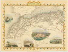
Ancient Africa or Libya Part I, produced by the Society for the Diffusion of Useful Knowledge (SDUK) and published in London in 1845, is an intricate depiction of the Western Mediterranean region, delineating the African coastline from Menix Island and Pons Zita, extending southwards beyond the Atlas Mountains to the Atlantic Coast. This representation stands out as one of the most detailed atlas maps of its era, capturing the geography of the region with notable precision.
The mid-19th century was a period of exploration, colonial ambition, and the desire to accumulate knowledge about the far reaches of the world. Africa, often referred to as the "Dark Continent" in Victorian discourse, was at the forefront of European interests, both for its economic potential and the mysteries it held. This map captures a fragment of that vast continent, illustrating a portion of its intricate coastline, filled with key locations that were likely vital for trade, navigation, and colonial endeavors.
The SDUK, a significant organization of its time, was committed to the broad dissemination of knowledge, and their maps were emblematic of this mission. With its rich detail, Ancient Africa or Libya Part I serves not only as a geographical guide but also as an embodiment of the 19th-century quest for understanding and documenting the world. The map's focus on the Western Mediterranean region, a crucial area for maritime activity, underscores the significance of this water body as a nexus of commerce, culture, and interaction between Europe and Africa.
The choice to detail regions such as Menix Island, Pons Zita, and the stretch south of the Atlas Mountains reveals the cartographic emphasis of the era: a balance between showcasing known trade routes and shedding light on lesser-known geographies. This meticulous delineation offers a window into both the topographical interests of the 19th-century cartographers and the geopolitical nuances of the time, illustrating the intertwining of geography with history and politics.
![Barbaria [with] Cartaginis sive potius Tunetani celeberrimi Sinus nec non fortalitij . . . [with] [Untitled map of Egypt]](https://storage.googleapis.com/raremaps/img/small/72788.jpg)
![Il Gerbi [Borj El Kebir, Tunisia]](https://storage.googleapis.com/raremaps/img/small/73716.jpg)