|
||

|

|
|

|
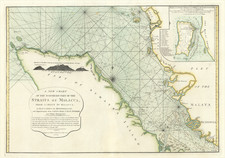
This detailed Chart of the Western Coast of Sumatra from Touroumane to Indrapour, published by Laurie & Whittle on 12 May 1794, stands as a significant East Indies navigational aid of the late 18th century. The map offers substantial insights into the coastal geography of Sumatra and its adjacent islands, with noteworthy contributions from Captain Joseph Huddart and Mr. Sampson Hall.
This chart represents the preeminent role of the British in maritime navigation and exploration in the late 18th century, a time when the East Indies were a hotbed of colonial endeavors. The inclusion of navigational and topographical data from the Neptune Oriental underscores the British Empire's use of accumulated global maritime knowledge in their charting efforts.
The map stands out with its carefully observed and finely engraved details of the western Sumatran coast. It includes insets of Se-Leaga Bay and Tappanooly Bay, providing an intimate understanding of these strategic locations. A special addition is the detailed Plan of Nattal, further communicated by Huddart and Hall, a testament to the extent of their navigation and exploration.
Adding a touch of first-hand maritime experience, the chart also features an account by Mr. Hall documenting an incident that occurred on 23rd August 1784. This narrative describes the encounter of the ship Royal Bishop with a shoal of coral rocks, providing a fascinating glimpse into the dangers and unpredictability of seafaring at the time. Hall's account not only exemplifies the seafarers' resilience but also underlines the critical role such incidents played in augmenting the accuracy of future charts.
The Chart of the Western Coast of Sumatra from Touroumane to Indrapour thus represents not just a mere geographical depiction, but a compendium of scientific observations, firsthand experiences, and the seafaring knowledge of the era. Its contributions to the maritime cartography of the East Indies make it an important artifact of maritime history and colonial exploration.
Robert Laurie (ca. 1755-1836) and James Whittle (1757-1818) formed their Fleet Street, London-based firm upon the 1794 death of their employer Robert Sayer, himself one of the dominant print and mapmakers of the last half of the 18th century.
Laurie & Whittle started managing Sayer's business as early as 1787. They took over all managerial duties when Sayer's health flagged in 1792, and they changed the imprint in 1794 upon his death. Sayer left the two a 21-year lease on the shop (at £100 a year) and on Sayer's Bolt Court premises, as well as an option to acquire stock and equipment at a preferential price of £5,000 payable over three years.
Robert Laurie retired from the firm in 1812, and his role was assumed by his son, Richard Holmes Laurie (1777-1858). The younger Laurie worked with James Whittle until the latter died in 1818. After R. H. Laurie died in 1858, Alexander George Findlay, FRGS (1812-1875) purchased the firm from his daughters. The firm continues today under another name, specializing in yachting charts.
Laurie & Whittle were prolific print and map publishers, and throughout their careers, they produced numerous very important and rare works. They carried on Robert Sayer's atlas business and were responsible for editions of The Complete East-India Pilot and The American Atlas.
![[ Spice Islands ] Insulae Molucae](https://storage.googleapis.com/raremaps/img/small/97227.jpg)