|
||

|

|
|

|
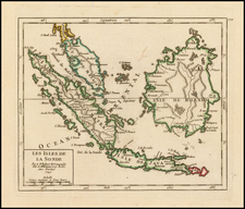
Fine large format map of the Makassar Strait, the perilous stretch of water lying between Borneo and Sulawesi.
Originally published in Laurie and Whittle's East Indian Pilot, one of the most important 18th-century navigational works to focus on Southeast Asia, the map shows the Strait in impressive detail. Toponyms along both islands appear in, as do the recorded tracks of some half dozen vessels that crossed the Strait. Soundings, reefs, coastal profiles, and more are provided.
An inset map to the left shows the shoals between "Rugged" and "Shoals" points, which is today where the border between East and South Kalimantan provinces meets the coast. Notes appear throughout, and enlarged coastal profiles can be seen along the side of the map.
Laurie and Whittle and the East Indian Pilot
Produced by the partnership of Robert Laurie and James Whittle, who took over Robert Sayer's business in 1794, this chart and the East India Pilot series it belongs to were important navigational resources during the height of British seafaring trade and exploration in the East Indies. It reflects the significant efforts of Laurie & Whittle to provide accurate, practical maps for maritime navigation, particularly in the highly trafficked, strategically critical waters of present-day Indonesia.
The partnership of Laurie and Whittle, later taken over in full by Richard Holmes Laurie, marked a critical phase in the history of British cartography characterized by the advent of modern, scientific topography. They collaborated with many of the other foremost British mapmakers of the day, including Kitchin, Faden, and Jefferys.
Robert Laurie (ca. 1755-1836) and James Whittle (1757-1818) formed their Fleet Street, London-based firm upon the 1794 death of their employer Robert Sayer, himself one of the dominant print and mapmakers of the last half of the 18th century.
Laurie & Whittle started managing Sayer's business as early as 1787. They took over all managerial duties when Sayer's health flagged in 1792, and they changed the imprint in 1794 upon his death. Sayer left the two a 21-year lease on the shop (at £100 a year) and on Sayer's Bolt Court premises, as well as an option to acquire stock and equipment at a preferential price of £5,000 payable over three years.
Robert Laurie retired from the firm in 1812, and his role was assumed by his son, Richard Holmes Laurie (1777-1858). The younger Laurie worked with James Whittle until the latter died in 1818. After R. H. Laurie died in 1858, Alexander George Findlay, FRGS (1812-1875) purchased the firm from his daughters. The firm continues today under another name, specializing in yachting charts.
Laurie & Whittle were prolific print and map publishers, and throughout their careers, they produced numerous very important and rare works. They carried on Robert Sayer's atlas business and were responsible for editions of The Complete East-India Pilot and The American Atlas.
![[ Spice Islands ] Hila en de Fortres Amsterdam | Nieuwe Morrsche Tempel van Hila | De Fortres Rotterdam op Larike | De Pas Baguwala en de Vesting Middelburg.](https://storage.googleapis.com/raremaps/img/small/77308.jpg)