|
||

|

|
|

|
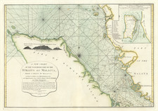
Sketch of the Straits of Gaspar, By J Huddart. 1788 is a highly detailed sea chart published by Laurie & Whittle in London on May 12, 1794. Focusing on the Straits of Gaspar, located between the Bangka-Belitung Islands and Sumatra in today's Indonesia, the chart exhibits the precision and detail needed by sailors of the time. Interesingly, this chart takes in only the strait east of Bangka.
The map includes a gestural depiction of the southeast coast of Banka (today's Bangka), Salt (Lepar) Island, Middle (Liat) Island, and a section of Long (Mendanau) Island. Apart from the main landforms, the chart also displays a host of smaller islands scattered throughout the straits.
In addition to the islands, the chart showcases numerous sailing channels and soundings — key information for mariners to understand water depth and potential navigational hazards. These soundings would have been crucial for the captains and crews navigating these waters, which could shift from deep to shallow quite rapidly.
Adding to the visual richness and practical utility of the map are several profile views. These profiles provide a visual cue to sailors, helping them identify specific features of the coastline from a distance.
For its time, this chart was one of the most detailed and up-to-date maps of the Straits of Gaspar, serving as a vital navigational tool for those sailing these waters.
Robert Laurie (ca. 1755-1836) and James Whittle (1757-1818) formed their Fleet Street, London-based firm upon the 1794 death of their employer Robert Sayer, himself one of the dominant print and mapmakers of the last half of the 18th century.
Laurie & Whittle started managing Sayer's business as early as 1787. They took over all managerial duties when Sayer's health flagged in 1792, and they changed the imprint in 1794 upon his death. Sayer left the two a 21-year lease on the shop (at £100 a year) and on Sayer's Bolt Court premises, as well as an option to acquire stock and equipment at a preferential price of £5,000 payable over three years.
Robert Laurie retired from the firm in 1812, and his role was assumed by his son, Richard Holmes Laurie (1777-1858). The younger Laurie worked with James Whittle until the latter died in 1818. After R. H. Laurie died in 1858, Alexander George Findlay, FRGS (1812-1875) purchased the firm from his daughters. The firm continues today under another name, specializing in yachting charts.
Laurie & Whittle were prolific print and map publishers, and throughout their careers, they produced numerous very important and rare works. They carried on Robert Sayer's atlas business and were responsible for editions of The Complete East-India Pilot and The American Atlas.