|
||

|

|
|

|
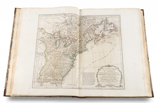
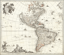
America, a striking map of the Americas published by John Thomson in 1815 in Edinburgh, conveys a compelling blend of known and speculative geography during a period of rapid exploration and discovery. One of the most distinctive characteristics of this cartographic piece is its representation of the Missouri River's headwaters and the extensive network of speculative tributaries leading to the Rocky Mountains.
In the early 19th century, the Americas remained a territory of fascination and uncertainty, a vast, largely uncharted space rich with potential for exploration and expansion. Thomson's map bears witness to this intrigue, especially in its portrayal of North America's interior. Drawing heavily from the reports of Peter Fidler, a cartographer and surveyor for the Hudson's Bay Company, the map traces a myriad of possible river courses westward, suggesting the possibility of a water route or portage through the Rocky Mountains to the Pacific Ocean—a notion that held significant implications for commerce and territorial claims.
While the North American interior leaves much to conjecture, the South American geography is rendered with considerable precision, indicative of the era's scientific progress and colonial engagements. Another noteworthy feature is the depiction of the South Pacific, where a cluster of islands is labeled as the "Dangerous Archipelago," suggesting the hazards faced by maritime explorers in this remote region.
The map also acknowledges the recent discovery of the Hawaiian archipelago, designated as the "Sandwich Isles," honoring Captain Cook's designation. The inclusion of the coastlines of Europe and northwest Africa further situates the Americas within a broader global context. As such, Thomson's America serves not only as a navigational tool but also as a document reflecting the ongoing quest for knowledge and control during the Age of Exploration.
John Thomson (1777-ca. 1840) was a commercial map publisher active in Edinburgh. He specialized in guide books and atlases and is primarily known for his Atlas of Scotland (1832) and the New General Atlas, first published in 1817 and reissued for the next quarter century. The New General Atlas was a commercial success—it was also published in Dublin and London—and it compiled existing geographic knowledge in compelling ways for a wide audience.
His Atlas of Scotland introduced new geographic information and was the first large-scale atlas of Scotland to be organized by county. It provided the most-accurate view of Scotland available before the Clearances. Work on the atlas began in 1820 and led to Thomson’s bankruptcy in 1830 due to the high costs of gathering the latest surveys and reviewing the required materials. Despite the publication of the atlas, Thomson declared bankruptcy again in 1835.