|
||

|

|
|

|
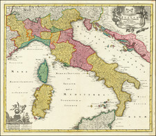
The Best Map of Italy of its Time. By One of Napoleon's Closest Confidants.
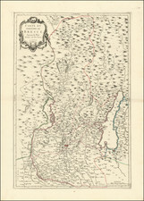
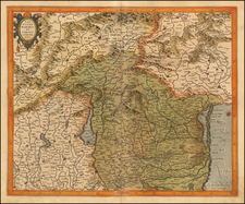
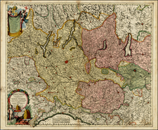
A beautiful cased example of Bacler D'Albe's combined 54-sheet map of northern and southern Italy, the first homogenous map of that country, one of the defining feats of French Napoleonic cartography.
The Napoleonic period was characterized by a realization that empirical and cutting-edge cartography was a key aspect of battlefield success, tactical genius, and the ruling of an empire. Many regional maps were produced throughout Europe at the behest of Napoleon during this period, but perhaps none is as monumental as Bacler D'Albe's Italian masterwork.
Bacler D'Albe, as part of Napoleon's inner circle, had access to more Italian geographical information than any predecessor. He occupied several roles in the Napoleonic imperial administration, including director of the Depot de la Guerre (the position he held while making this map) and director of the emperor's personal topographic office.
D'Albe served the emperor from the beginning to the end: they fought together at the Siege of Toulon in 1793, and Napoleon would leave D'Albe in charge of the education of his son in his will. Napoleon particularly prized D'Albe for his ability to transform his topographic knowledge into battlefield scenarios: given a map of a region, D'Albe would sketch out for the emperor various battlefield views and situations. As such, D'Albe was credited by the French military historian General Bonnal as "the laboratory in which the ideas of Napoleon were germinated" and by the Belgian historian Ronald Pawly as "the second most important person in the Imperial headquarters" after Napoleon himself.
His most notable contribution is perhaps the "Carte Générale du Théâtre de la Guerre en Italie et dans les Alpes" ("General Map of the Theatre of War in Italy and the Alps"), which documented the progression of French forces from the Var River to Rome during the French Revolutionary Wars. This map, known for its meticulous detailing and high accuracy, brought him widespread acclaim.
Prospectus
Bacler D'Albe published a prospectus and list of subscribers for the map, which begins by reading:
L'Italie jusqu'à ce jour fut divisée en une infinité de petits états, que la politique des princes qui les gouvernaient, n'a jamais laissé connaître à leurs voisins, par un motif bien simple, celui de leur faiblesse. Aussi ne trouve-t-on en Italie presque point de bonnes cartes géographiques. Les cartes générales que les étrangers ont dressées, sont trop petites et trop peu détaillées pour être utiles. Les bonnes cartes particulières sont rares ou ensevelies dans l'obscurité.
Les Alpes, ces grandes limites naturelles, qui semblent avoir circonscrit la science comme les peuples qu'elles renferment, ne sont connues que partiellement. Il n'existait point une seule bonne carte générale. Une telle carte intéresserait cependant les nations auxquelles elles servent ou d'enceinte ou de barrières."
This translates as:
Italy, until this day, was divided into a multitude of small states, the politics of the princes who governed them never allowed their neighbors to know them, for a very simple reason, their weakness. Hence, almost no good geographical maps are found in Italy. The general maps that foreigners have drawn are too small and too little detailed to be useful. Good particular maps are rare or buried in obscurity.
The Alps, these great natural limits, which seem to have circumscribed the science like the peoples they contain, are only partially known. There was not a single good general map. Such a map would, however, interest nations for whom they serve as enclosures or barriers."
The Revolutionary Wars
The map of northern Italy, as suggested in the title, serves not only to reinvent the cartography of the region but also to document Napoleon's victories and advances from Toulon to Rome. A key in the lower part of the map shows just how detailed this record is: not only are battles marked, but the generals who participated in them, the fortifications made, and the types of attacks conducted.
The lower right sheet of the map is further entirely devoted to providing a diary of the campaigns in Italy, from the first year of the Republic through to the Second Italian Campaign in Year 8 of the Republic.
The Emporer's Map
The Carte Generale du Theatre de la Guerre and the Carte Generale des Royuames were but the first - and only surviving - step in the construction of Bacler D'Albe's now-lost masterwork: a 1:100,000 scale homogenous mapping of all of Europe. This monumental piece, which had dimensions stretching well over 100 feet, was completed in three years between 1809 and 1812. Titled The Map of the Emperor, Napoleon brought it on his ill-fated campaign against Russia, where the map was lost.
Baron Louis Albert Guislain Bacler d'Albe
Born in 1761 in Saint-Pol-sur-Ternoise, Bacler d'Albe was a distinguished French military officer, cartographer, and painter. He showed an early affinity for the arts, particularly painting, and focused his early work on the Mont Blanc region of the Alps. However, the tumultuous period of the French Revolution marked a significant shift in his life trajectory, propelling him into the military arena.
In 1792, at the onset of the French Revolutionary Wars, Bacler d'Albe joined the French army as a Captain of the Gunners. Throughout the campaign, he was attached to General Napoleon Bonaparte, serving as his Engineer-Geographer and the Head of his Topographic Office. This appointment marked the beginning of a long association between Bonaparte and Bacler d'Albe, wherein the latter proved instrumental in Napoleon's military successes. Bacler d'Albe created detailed, strategic maps that became vital tools for planning military operations. He developed an innovative technique for real-time mapping of battlefields, allowing Napoleon to have an accurate understanding of the geographical layout of a region and to make more informed strategic decisions.
Bacler d'Albe continued to serve Napoleon even after the latter became Emperor. He was appointed as an aide-de-camp to Napoleon in 1804 and was subsequently elevated to the rank of Baron in 1809, in recognition of his unwavering loyalty and significant contributions. His relationship with Napoleon lasted until the Emperor's abdication in 1814, after which Bacler d'Albe retired from military life.
Provenance
The key sheets affixed to the linen bear the inscription:
De la biblioteque de M. de Kemlandt 1812
This would appear to be the Romain-Joseph de Brigode-Kemlandt, Baron of the Empire (1775 - 1854), who was a deputy from the Nord in the Assemblée National and mayor of Annappes. He married the granddaughter of the Marquis de Lafayette, Célestine Louise Henriette de Fay de La Tour-Maubourg.
![[Liguria] Le cours du Torran de la Rossa depuis la Source jusqu'a Albinga avec les Communications sur le Canaro Le 15 juin 1745.](https://storage.googleapis.com/raremaps/img/small/87658op.jpg)