|
||

|

|
|

|
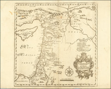
Highly detailed map of the Middle East, published in 1967 as international interest in the region was rising with the Six Day War.
The map shows the greater Middle East, including northeast Africa, Persia, and Anatolia. Yemen, the Federation of South Arabia, and the Protectorate of South Arabia, all split the region currently controlled by Yemen. Further East, Oman is divided between the "Muscat and Oman" and "Truccial Oman." A neutral zone splits Iraq from Saudi Arabia.
The Six-Day War, fought from June 5 to 10 in 1967, marked a pivotal moment in Middle Eastern history. Israel, acting preemptively in response to imminent threats from Egypt, Syria, and Jordan, executed a swift and powerful military campaign that radically altered the region's geopolitical landscape. In an impressive demonstration of strategic precision and might, Israel decimated the Arab air forces on the first day, paving the way for rapid territorial gains, which included the Sinai Peninsula, the West Bank, and the Golan Heights. The war's outcome significantly expanded Israel's size, sowed the seeds for ongoing conflict, and fundamentally reshaped the dynamics of the Middle East.
Edward Stanford (1827-1904) was a prominent British mapmaker and publisher. A native of Holborn in the heart of London, Edward was apprenticed to a printer and stationer at the age of 14. After his first master died, he worked with several others, including Trelawny W. Saunders of Charing Cross. Saunders oversaw young Edward’s early career, ensuring that he became a Fellow of the Royal Geographical Society. Associations with the Society eventually brought Sanders much business and gave him a reputation as a publisher of explorers. As testament to this reputation, the Stanford Range in British Columbia was named for him by John Palliser.
Stanford briefly partnered with Saunders in 1852 before striking out on his own in 1853. He was an agent for the Ordnance Survey, the Admiralty, the Geological Survey, the Trigonometrical Survey of India, and the India Office. He also controlled the maps of the Society for the Diffusion of Useful Knowledge, another lucrative source of income. In 1857, Stanford founded his namesake Geographical Establishment, with Saunders and A. K. Johnston as engravers. Thereafter, Stanford was known for his “library maps”, particularly those of Africa and Asia.
Addresses and Years of Operation:
- 6 Charing Cross, London (1848): Edward Stanford's initial place of employment at Trelawney Saunders' shop.
- 7 and 8 Charing Cross, London (1853): Stanford expanded his shop to these addresses.
- 55 Charing Cross, London (1873): The shop moved to this larger location.
- 12-14 Long Acre, London (1873): Site of the new print works and current flagship store.
- 7 Mercer Walk, London (2019): Stanfords moved to this address, continuing its legacy.
Stanford's work with Chief Cartographer John Bolton, including the 1858 Library Map of Europe, positioned the company as a leader in quality cartography during a time of exploration and colonialism. Their 1862 Library Map of London earned acclaim from the Royal Geographical Society. With the business thriving, Stanford purchased Staunton & Son in 1877 and, upon retiring in 1885, handed over the reins to his son, Edward Stanford II.
As sole agents for Ordnance Survey Maps, the company's influence and reputation grew, culminating in the Stanford’s London Atlas Of Universal Geography, which was presented to Queen Victoria in 1887. The transition into the 20th century saw further integration of retail, print, and cartographic operations at Long Acre.
During World War I, Stanford's became an essential publisher for the War Office. Edward Fraser Stanford took over in 1917, steering the company through the interwar period and innovations, such as the world’s smallest maps in 1922 and the Daily Mail Motor Road Map in 1926.
Withstanding a bombing in WWII, the company continued under the stewardship of John Keith Stanford and was sold to George Philip & Son in 1947. As it adapted to the digital age, Stanfords received the Ordnance Survey Premier Partner status in 2007 and ventured into online mapping and data services.
Stanfords, now an icon for travellers and explorers, has maintained its cultural relevance and retail success well into the 21st century, underpinned by a legacy of entrepreneurial spirit and commitment to cartographic excellence.
![[ Turkish Empire ] Imperium Turcicum Complectens Europae, Asiae, et Africae, Arabiae que Regiones ac Provincias Plurimas Industria et Labore . . .](https://storage.googleapis.com/raremaps/img/small/104260.jpg)
![Syrie Ancienne [shows Cyprus]](https://storage.googleapis.com/raremaps/img/small/89269.jpg)
![Asia [with inset:] Palestine or the Holy Land.](https://storage.googleapis.com/raremaps/img/small/93612.jpg)