|
||

|

|
|

|
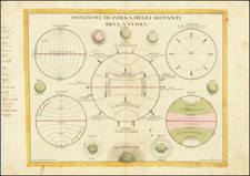
The instructional wall chart, "The Rotating Globe I 24 Hours - Day and Night," created by Pictorial Charts for G.B. Instructional, offers a clear and straightforward depiction of the Earth's rotation and its impact on our perception of time. Published as part of the Geography Series by the Chart Section of the G.B. Instructional Ltd's Education Division in London, this diagrammatic portrayal of the terrestrial rotation stands as a fundamental tool for understanding global time zones and the universal phenomena of day and night.
The wall chart serves as a vivid graphical representation of the Earth's daily rotation around its axis, illuminating the science behind the progression of day into night and vice versa. By depicting the Earth's spin from West to East, the chart illustrates the resulting solar phenomena, wherein the Sun appears to rise in the East and set in the West. Moreover, the chart emphasizes the fact that while one hemisphere of the Earth basks in sunlight, the opposite hemisphere is shrouded in darkness, exemplifying the dichotomy of day and night that characterizes our terrestrial experience.
Additionally, we are separately offering the companion chart "The Rotating Globe II 1 Year - Unequal Day & Night," providing a more comprehensive understanding of Earth's movements not only in terms of its rotation but also its annual revolution around the Sun. The duality of these charts serves as a testament to the pedagogical intention behind their creation, aimed at demystifying the Earth's complex celestial ballet for educational purposes.
While this chart may be appreciated for its visual and educational merits, it also holds a deeper historical value, being a reflection of mid 20th-century educational methods and materials. As such, it serves as a window into the evolution of pedagogy, demonstrating how complex concepts were made accessible to a broad audience.
![Apollo Earth Orbit Chart (AEO) Apollo Mission 8. Sheet 1 of 3, Contains Revolution 1. For December 1968 Launch Dates [with:] Sheet 2 of 3, Contains Revolution 2. For December 1968 Launch Dates [and: Sheet 3 of 3, Contains Revolution 3. For December 1968 Launch Dates]](https://storage.googleapis.com/raremaps/img/small/95707.jpg)
![[ Crater ]](https://storage.googleapis.com/raremaps/img/small/70467.jpg)