|
||

|

|
|

|
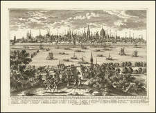
Original city plan of Berlin published at the close of the Second World War, showing how the city was divided between French, English, American, and Russian sectors.
Major points of military interest, including airfields, headquarters, and centers of military government are all marked. Neighborhoods are named and demarcated in red. Major arteries are named, with parks, rivers, and other points of geographical importance all shown. An inset plan in the upper right shows the wider Berlin region.
In 1945, Berlin found itself in a state of profound upheaval and occupation following the end of World War II. The city had suffered immense devastation due to relentless Allied bombings and fierce urban warfare during the final stages of the war. As the war drew to a close, Berlin became a focal point of contention between the victorious Allied powers—namely, the United States, the Soviet Union, Great Britain, and France. The city was ultimately divided into four occupation zones, each controlled by one of the Allied powers. The Soviet Union took control of the eastern part, while the western sectors were governed by the United States, Great Britain, and France. This division sowed the seeds for the future Cold War, as tensions between the Soviet Union and the Western Allies escalated and deepened. The situation in occupied Berlin was characterized by post-war chaos, widespread scarcity, and the daunting task of rebuilding a city in ruins. It was against this backdrop that the seeds of the Cold War were planted and Berlin became a symbol of the ideological and political divide that would shape the world for decades to come.
![[Napoleon's Battles in France, Belgium Netherlands, Luxembourg, Germany] No. 1 Frontiere du Nord. Mesny 5.](https://storage.googleapis.com/raremaps/img/small/60727.jpg)
![(First state!) [ Upper Rhine River Valley -- Strasbourg to Basle ] Alsatia et Brisgoia II Rheni Et VII Nova Tabula](https://storage.googleapis.com/raremaps/img/small/94641.jpg)