|
||

|

|
|

|
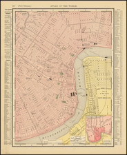
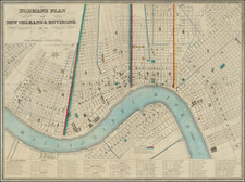
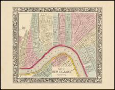
This 1892 Map of New Orleans, by Rand McNally & Co., is a comprehensive representation of the city, offering intricate details from the fairgrounds to major buildings. This Chicago-published map captures the city's urban blueprint at the turn of the 20th century, presenting a historical snapshot of New Orleans's layout, transport networks, and social infrastructure.
Providing a nuanced depiction of the city, the map extensively outlines elements such as streets, railway lines and depots, ferries, piers, along with notable structures such as courthouses and hospitals. Each detail is recorded, offering viewers a sense of the urban fabric of late 19th-century New Orleans, and provides insight into the development and organization of the city.
From a historical perspective, the map marks an era of great growth and development in New Orleans, coming in the wake of the city's recovery from the Civil War and its evolution into a prominent commercial and cultural hub. It encapsulates the flourishing urbanism of the period, marked by the city's distinctive architecture and burgeoning transportation infrastructure.
Rand McNally & Co. is a large American map and navigation company best known for its annual atlases. The company got its start in 1856, when William Rand opened a print shop in Chicago. He was joined in 1858 by a new employee, Andrew McNally. Together, the men established their namesake company in 1868. Originally, the company was intended to print the tickets and timetables for the trains running to and through Chicago; their first railway guide was published in 1869.
By 1870, they had shifted from just printing to publishing directories, travel guides, and newspapers. Their first map appeared in 1872 in a railway guide. The map was produced using a new wax engraving method, a cheaper process that gave the company an edge.
By 1880 Rand McNally had entered the education market with globes, wall maps, and geography texts for students. In 1923, Rand McNally published the first Goode’s World Atlas, named after its editor, Dr. J. Paul Goode. For generations afterward, this would be the standard classroom atlas.
In 1899, William Rand left the company, but McNally and his family remained, controlling the company for over a century. In 1904, they published their first road map intended for automobiles and by 1907 were publishing Photo-Auto Guides, which combined photography and mapping to help drivers. In 1924, they produced the Auto Chum, a precursor to their famous road atlases. Rand McNally would remain the leader in road maps and atlases throughout the twentieth century.
In 1937, Rand McNally opened its first store in New York City. Ever on the frontier of technology, Rand McNally pioneered the scribing process for printing tickets in 1958 and printed their first full-color road atlas in 1960. Arthur Robinson developed his now-famous projection of Rand McNally in 1969. By the 1980s, the company was exploring digital reproduction and digital databases of maps for truckers. In the 1990s, they lead the charge to develop trip-planning software and websites. Today, most of its products are available online or in a digital format, including maps for tablets and phones.
![[ St. Henry's Church, New Orleans and Mission ] La Mission de St. Henri, Diocese de la Nouvelle-Orleans (Etats-Unis)](https://storage.googleapis.com/raremaps/img/small/99740.jpg)
![Colton's The City of Louisville [with] Colton's The City of New Orleans](https://storage.googleapis.com/raremaps/img/small/100352.jpg)