|
||

|

|
|

|
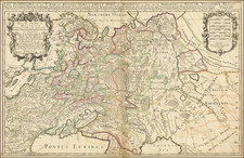
Herman Moll's map is a simple but well-detailed cartographic representation of Northeast Germany during the early 18th century.
In the first part of the 18th century, the dominions illustrated on this map played key roles in shaping Europe's political landscape. The Electorate of Brandenburg, under the House of Hohenzollern, contributed to the creation of the future Kingdom of Prussia. The military growth and diplomatic strategies of the Hohenzollerns are subtly reflected in Moll's map, providing an insight into their growing influence.
The Electorate of Saxony, controlled by the House of Wettin, was a notable cultural hub in the region. The map's meticulous detailing of Saxony's cities and landmarks suggests the region's cultural richness and urban development.
The Duchy of Mecklenburg, with its clear boundaries on the map, was a significant Northern power during the period. Its strategic location near the Baltic Sea and its control over crucial trading routes are evident in Moll's map, reflecting the Duchy's economic importance.
Pomerania, spanning the southern coast of the Baltic Sea, was a divided region between Sweden and Brandenburg-Prussia. Its depiction in the map indicates the geopolitical tensions of the time, with the well-defined boundaries highlighting the territorial dispute.
Lastly, Silesia, currently mostly part of Poland, was a highly coveted region due to its rich natural resources and strategic position. Its clear demarcation on Moll's map showcases the significant role it played in the geopolitics of the region.
Herman Moll (c. 1654-1732) was one of the most important London mapmakers in the first half of the eighteenth century. Moll was probably born in Bremen, Germany, around 1654. He moved to London to escape the Scanian Wars. His earliest work was as an engraver for Moses Pitt on the production of the English Atlas, a failed work which landed Pitt in debtor's prison. Moll also engraved for Sir Jonas Moore, Grenville Collins, John Adair, and the Seller & Price firm. He published his first original maps in the early 1680s and had set up his own shop by the 1690s.
Moll's work quickly helped him become a member of a group which congregated at Jonathan's Coffee House at Number 20 Exchange Alley, Cornhill, where speculators met to trade stock. Moll's circle included the scientist Robert Hooke, the archaeologist William Stuckley, the authors Jonathan Swift and Daniel Defoe, and the intellectually-gifted pirates William Dampier, Woodes Rogers and William Hacke. From these contacts, Moll gained a great deal of privileged information that was included in his maps.
Over the course of his career, he published dozens of geographies, atlases, and histories, not to mention numerous sheet maps. His most famous works are Atlas Geographus, a monthly magazine that ran from 1708 to 1717, and The World Described (1715-54). He also frequently made maps for books, including those of Dampier’s publications and Swift’s Gulliver’s Travels. Moll died in 1732. It is likely that his plates passed to another contemporary, Thomas Bowles, after this death.
![(Ukraine, Poland, Russia, Georgia, Armenia) [Tabula II Asiae]](https://storage.googleapis.com/raremaps/img/small/102937.jpg)
![[ Siege of Krakow ] Was gestalt des Koniges in polen Sigismundi Braut Anna Caroli, Ertzhertzogen Von Osterreich Christmilter gedechnus Tochter, den 28 Mayus. 92 bij Crocaw . . .](https://storage.googleapis.com/raremaps/img/small/98964.jpg)