|
||

|

|
|

|
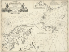
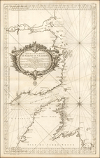
Scarce German Plan of Quebec
The plan of Quebec from 1758 is a detailed representation of the city during the French colonial period. It shows the city's fortifications, a key characteristic of Quebec's layout during this era. A key on the right side of the map identifies major buildings and other significant sites, offering a sense of the city's infrastructure and the distribution of its public and military facilities.
The map's meticulous portrayal of Quebec's fortifications is particularly notable. These fortifications reflect the strategic significance of Quebec, a city often contested by European powers in North America. Detailed representation of ramparts, bastions, and city gates suggests a city prepared for potential siege, underscoring the tense geopolitical environment of the period.
Adding to the historical importance of this map, the map is based on a plan drawn up during the visit of Pierre François-Xavier de Charlevoix to America. In 1720, the Jesuit scholar and explorer was sent by the Duke of Orleans to record events in New France and Louisiana and identify the best route to the Pacific Ocean. Gathering geographic information from fur traders in Quebec and journeying through the Great Lakes and down the Mississippi River, Charlevoix accumulated a wealth of knowledge about the North American landscape.
Upon his return to France, Charlevoix documented his observations in his work Histoire et description générale de la Nouvelle France, which has become a seminal resource on North America in the pre-French & Indian (Seven Years) War era.
Jacques-Nicolas Bellin (1703-1772) was among the most important mapmakers of the eighteenth century. In 1721, at only the age of 18, he was appointed Hydrographer to the French Navy. In August 1741, he became the first Ingénieur de la Marine of the Dépôt des cartes et plans de la Marine (the French Hydrographic Office) and was named Official Hydrographer of the French King.
During his term as Official Hydrographer, the Dépôt was the one of the most active centers for the production of sea charts and maps in Europe. Their output included a folio-format sea atlas of France, the Neptune Francois. He also produced a number of sea atlases of the world, including the Atlas Maritime and the Hydrographie Francaise. These gained fame and distinction all over Europe and were republished throughout the eighteenth and even in the nineteenth century.
Bellin also produced smaller format maps such as the 1764 Petit Atlas Maritime, containing 580 finely-detailed charts. He also contributed a number of maps for the 15-volume Histoire Generale des Voyages of Antoine François Prévost.
Bellin set a very high standard of workmanship and accuracy, cementing France's leading role in European cartography and geography during this period. Many of his maps were copied by other mapmakers across the continent.