|
||

|

|
|

|
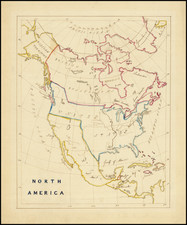
The 1834 French map of North America offers a detailed representation of the American West in an era of discovery and expansion. Showcasing the Republic of Texas, the map indicates a period prior to its annexation by the United States. The map carries a sense of historicity as it provides a window into the past, offering a visual manifestation of geopolitical dynamics in the early 19th century.
This map contains a commendable level of detail in the Rocky Mountains, a testament to the contributions of Alexander von Humboldt and Major Stephen H. Long. The meticulously illustrated mountain range highlights the influence of Humboldt's exhaustive studies and Long's explorations, showcasing the nuanced topography of the region.
The mid-continental details of the map are also remarkable, offering intricate renderings of the landscape before it was further mapped and studied by Joseph N. Nicollet. The depictions are testament to the limited knowledge and the immense curiosity of the era, projecting an alluring combination of fact and conjecture.
Moving west of the Rockies, the map becomes even more intriguing, harboring myth and mystery. It features the apocryphal second Salt Lake and enigmatic rivers, purported to connect the two Salt Lakes to the Pacific Ocean. These speculative geographical features highlight the speculative nature of cartography during the period, embodying the enduring human desire to understand and navigate the unknown.
In essence, the 1834 French map of North America is a reflection of the time it was created in, capturing the curiosity, wonder, and limited knowledge of the era. It embodies the essence of the American West as it was understood in the early 19th century - a region of intrigue, discovery, and boundless possibilities.
![[First State of the Popple Key Sheet] A Map of the British Empire in America with the French and Spanish Settlements adjacent thereto by Hen. Popple.](https://storage.googleapis.com/raremaps/img/small/92714.jpg)