|
||

|

|
|

|
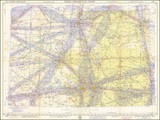
Regional Aeronautical Chart 15M Restricted is a valuable piece of historical air navigation cartography that covers key areas in Texas, including El Paso, Austin, Del Rio, San Antonio, and Corpus Christi. Compiled and printed in Washington, D.C. by the U.S. Coast and Geodetic Survey, it stands as a testament to the collaborative efforts between different government bodies, including the Mexican Government, U.S. Geological Survey, and Civil Aeronautics Administration.
The chart is dated December 16, 1943, indicating it was produced during World War II, a fact further evidenced by the warning note about potential changes or discontinuation of lights, radio facilities, and other aids to air navigation due to war conditions. Priced at 40 cents, it was primarily an aeronautical tool, designed to assist pilots and air navigation professionals during a time of significant global conflict.
The chart features various symbols and notations, representing different types of facilities and navigational aids. Airports are differentiated between military (Army, Navy, or Marine Corps) and civilian (Commercial or Municipal), and the presence of seaplane ports are also noted. Information about the beacons, including their type (rotating, flashing, etc.), and radio stations, including call letters and frequency, is provided.
In addition, it details other important landmarks and structures such as mooring masts, auxiliary lights, marine navigational lights, and prominent transmission lines. The chart also marks the location of marine radiobeacons and fan marker beacons, both vital for assisting in air navigation.
Civil airways are differentiated into controlled and uncontrolled, and areas of equal magnetic variation are outlined. Notably, the chart also marks anchorage areas, with indications about the available facilities at each location.
"Regional Aeronautical Chart 15M Restricted" is thus a crucial document reflecting the intersection of geographic knowledge and military necessity during wartime. Its detailed and specific notations underscore the importance of accurate and updated geographic information for aerial navigation, and it highlights the technological capabilities and constraints in aeronautical charting during the 1940s.