|
||

|

|
|

|
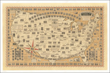
Mapping America’s Westward Expansion
In the early 19th century, America was on the cusp of great change, as evidenced by this school map issued shortly after the 1830 Census. This map, with its intricate details and annotations, provides an insightful glimpse into the United States' evolving geographical and political landscapes, underscoring the rapid westward expansion of the era.
One of the most striking features of the map is its elaborate distance chart at the lower right, which gives distances between major cities. This chart emphasizes the growing importance of western urban centers such as St. Louis and New Orleans, and the short lived importance of other western towns, including Vandalia, Illinois and New Albany, Indiana. This was a time when better infrastructure and transportation were making distances more meaningful, with steamboats and nascent railroads shrinking travel times and expanding horizons.
The map predates the establishment of Wisconsin Territory (1836) and Iowa Territory (1838). Interestingly, a significant part of southern Wisconsin is depicted as "attached to Michigan" Territory. The map pre-dates the Toledo War of 1835-1836.
Predominant on this map are the vast Native American regions that dominate the Midwest and Plains, an essential reminder of the original inhabitants of these lands. The District of Huron, Sioux District, Mandan District, Osage District, and Ozark District are significant territories broadly located within the expansive Missouri Territory. Each of these districts housed distinct indigenous tribes with their unique cultures:
-
The Huron District was home to the Wyandot or Huron tribes, known for their agricultural prowess.
-
The Sioux District belonged to the Dakota Sioux tribes, characterized by their fierce warrior culture and intricate social structures.
-
The Mandan District was inhabited by the Mandan people, known for their earth-lodge villages along the Missouri River.
-
The Osage and Ozark Districts covered lands of the Osage tribes, formidable hunters, and traders.
To the southwest, the freshly independent Mexico dominated the landscape, with an identifiable region named Texas. Cities like San Antonio, Galvezton, and Nacadoches are marked, yet there's no mention of Austin's colony, which Stephen F. Austin would establish later as part of an empresario contract with Mexico. This hints at the burgeoning Texan independence movement, culminating in the Texas Revolution in the mid-1830s.
The "Great Spanish Road to the Red River" and Santa Fe spotlight the integral trade routes of the era. Santa Fe, in particular, was the terminus of the Santa Fe Trail, a significant 19th-century trading route.
In the west, the majestic Rocky Mountains are aptly noted with Long's Peak, named after Major Stephen H. Long, an explorer who led expeditions in the region. Though the map showcases several western rivers like the Yellow Stone River and Big Horn River, it conspicuously omits vast territories, illustrating the uncharted expansiveness of the West during that period. Significantly, rivers named after presidents like Thomas Jefferson and James Madison highlight the young nation's deep reverence for its founders.
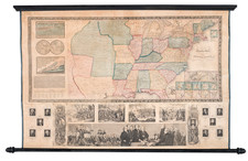
![[Separately Published Example!] Map of the United States of America. Designed to illustrate the Geological Memoir of Wm. Maclure Esq.](https://storage.googleapis.com/raremaps/img/small/90048.jpg)